2.1 Minnesota A History of the Land 2 When Minnesota Began Spending Its Inheritance
When Minnesota Began Spending Its Inheritance
Forest became farmland, prairie became wheat, wildlife became freight, and falling water became flour. Almost every improvement worked; almost every improvement also carried a consequence nobody had put on the invoice.
Minnesota did not change all at once. It changed the way landscapes often do when technology, markets, and ambition begin reinforcing one another: through a thousand practical decisions that seemed modest at the time.
A tree was cut to open a field, a rail line was pushed across the prairie, a mill wheel turned beneath falling water, and a carload of game headed toward buyers far beyond Minnesota. None of those acts, by itself, looked like the end of an ecological world. They looked like work, opportunity, and improvement. Together, however, they formed a system powerful enough to reorganize much of the state in only a few decades.
The documentary series Minnesota: A History of the Land frames this history around a powerful proposition: people act on landscapes according to what they believe those landscapes are for. [source] The land has its own answer, because forests, prairies, rivers, wildlife, and soils continue to behave as ecological systems whether anyone has priced those functions or not. Much of the history that follows unfolds in the gap between those two ways of understanding the same place.
What to carry with you
- Explain how different ideas of value can produce different land-use decisions on the same landscape.
- Describe how railroads and markets changed the scale of hunting, farming, logging, and milling in late nineteenth-century Minnesota.
- Explain why bison, fire, deep-rooted plants, and soil organisms were parts of a functioning prairie system rather than separate pieces.
- Trace the geographic chain connecting prairie soil, wheat, railroads, St. Anthony Falls, milling technology, and Minneapolis.
- Explain why the Great Hinckley Fire was produced by an interaction among weather, logging, fuel, settlement, and public policy rather than by weather alone.
Same place, different value
Choose a part of the landscape. Nothing physical changes. Only the observer does.
A layered deciduous forest whose shade, soils, animals, and trees reproduce one another over time.
Trees block the plow, but they can also become building material and cash. Clearing them reveals farmland.
The Big Woods: a place defined by shade
Across central and south-central Minnesota stood a broad deciduous forest of maple, basswood, oak, and elm. To understand what happened next, it helps to see the forest not as a collection of trees but as a system that created the conditions for more forest.
The Big Woods was not uniform. Wetter lowlands, drier uplands, different soils, different trees, and different animal communities formed a layered landscape, yet one feature connected much of it: shade. Maple seedlings, woodland flowers, soil moisture, and the cool understory all depended upon a canopy above them. Remove enough of that canopy and the result is not merely fewer trees; the conditions required to make the next generation of forest begin to disappear as well.
Dakota communities had long lived in and used this landscape as a homeland rather than as unused acreage. European newcomers often moved into the same country with a different set of needs and expectations. A mature tree could be shelter, fuel, construction material, or cash, but it could also be standing exactly where a crop field was supposed to go. The same acre therefore carried several kinds of value at once, and those values did not always point toward the same future.
That is why the settler's dilemma is more interesting than a simple story of good people and bad people. A family trying to build a house, find water, clear enough ground to farm, and survive a Minnesota winter had immediate reasons to cut. The ecological cost might take years to become obvious, while the need for food and income arrived at once. Enormous change can grow from ordinary decisions when nearly every incentive points in the same direction.
Minnesota before and after the great conversion
Drag the divider. The classifications differ, so this is not a pixel-for-pixel land-cover analysis. It is a broad comparison between ecological Minnesota around 1850 and a modern land-use landscape.


Market hunting: the railroad changes the arithmetic
The fur trade had already connected animals to commerce, but the railroad changed the scale. By shrinking the cost of distance, it turned wildlife that once belonged mainly to a local market into freight for buyers hundreds of miles away.
Before railroads, market hunters faced a stubborn geographical problem: meat spoiled, loads were heavy, and distant buyers were expensive to reach. Rail lines weakened all three constraints at once. A hunter could now connect to national markets, ship meat quickly enough to preserve its value, and make money from animals that local demand alone could never have absorbed. The railroad did not hunt anything, but it radically enlarged the economic radius of every hunter who could reach it.
The passenger pigeon became the terrible emblem of that new arithmetic. The species once numbered an estimated three to five billion in North America, with flocks so enormous that abundance itself seemed to be proof of permanence. Commercial hunting and habitat loss helped drive the population downward with astonishing speed. Once numbers collapsed, the pigeon's highly colonial breeding biology also made recovery more difficult. The last known passenger pigeon, Martha, died at the Cincinnati Zoo on September 1, 1914. [source]
From a sky full of birds to one bird in a zoo
Slide through four moments. The image changes because the history changes.
Abundance looks permanent
Huge flocks made the species seem impossible to exhaust. The danger was hidden by abundance itself.
The prairie was not empty. It was busy underground.
From a distance the prairie could look almost blank, but much of its machinery was hidden below the grass: deep roots, soil organisms, stored moisture, and centuries of growth and decay interacting with drought, fire, insects, and large grazers.
In a tallgrass prairie, a surprising share of the living system lies beneath the surface. Deep roots capture water, die back, regrow, and feed the organisms that build soil; fire restrains trees and shrubs; drought favors plants capable of waiting out scarcity. What looks like a simple grassland is actually a community maintained by repeated disturbance and recovery, with different processes operating above and below ground at the same time.
Bison were part of that machinery. Minnesota DNR describes them as ecosystem engineers because they grazed unevenly, trampled vegetation, rolled in wallows, redistributed nutrients, and left some patches short while others remained tall. People also used fire on the prairie, and the combination of grazing and burning helped create a shifting mosaic rather than one uniform field of grass. Bison were therefore not simply animals living on the prairie. Their behavior helped make the prairie behave as prairie.
What does a bison actually do to a prairie?
Click a behavior and follow the ecological chain.

Bison reduce the height and proportion of favored grasses. Grazing becomes patchy, which helps create variation across the prairie.
Then the plow arrives
Settlers looked at the prairie and saw deep black soil, and on that point they were absolutely right. The soil was extraordinary. The mistake was subtler: it was easy to imagine that fertility belonged to the soil itself, rather than to the long ecological process that had created and renewed it through roots, microorganisms, fire, grazing, decomposition, and time.
The plow broke the sod and interrupted that old relationship, replacing a community of many plants with agricultural land that increasingly centered on one crop: wheat. At first, the change looked like an astonishing success because farmers were planting into an ecological inheritance accumulated over centuries. High yields encouraged more plowing, more settlement, more rail construction, and more investment. The very success of the new system helped hide the fact that it was drawing down a form of natural capital it had not created.
Prairie → wheat
Slide through four genuinely different stages of the transformation.
Diverse prairie
Fire, drought, deep roots, many species, insects, grazers, and soil organisms form a resilient system.
Wheat, railroads, and the city at the falls
Once wheat becomes freight, the prairie is connected to Minneapolis. Once Minneapolis applies waterpower and new milling technology, a regional crop becomes a national and international commodity.
The Red River Valley became one of the grand stages of the wheat boom. Bonanza farms treated agriculture on an industrial scale, combining huge acreages with machinery, hired labor, management, and direct rail connections to markets. The former bed of Glacial Lake Agassiz had produced a landscape so flat that the horizon itself seemed to invite bigger machines and bigger ambitions.
The grain then moved southeast toward Minneapolis, where an older piece of physical geography was waiting. At St. Anthony Falls, falling water powered an increasingly sophisticated milling district. Minnesota wheat was no longer merely a crop growing in a field. It had become one component of a production network stretching from prairie soil through railroads and mills to consumers far beyond the state.
Technology made the connection more valuable. Minnesota's hard spring wheat initially produced darker, less desirable flour with older milling methods. In the 1870s, the middlings purifier and gradual-reduction milling helped turn northern spring wheat into high-quality white flour. The improvement did more than make better flour. It raised demand for wheat across the northern plains and strengthened the rail-and-mill system centered on Minneapolis. [source]
The chain becomes wonderfully improbable when followed backward. Ancient ice helps create a waterfall; the waterfall attracts mills; railroads bring wheat; milling technology turns hard spring wheat into desirable flour; flour builds fortunes, neighborhoods, and a city. Nobody designed the entire arrangement. Each improvement strengthened another link until prairie, railroad, river, factory, and market had become parts of one geography.
How a prairie becomes a flour capital
Click along the chain.
The scale of the wheat machine
Industrialization did not stop at the factory door.
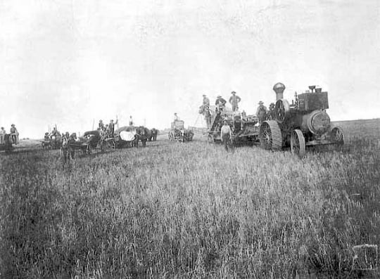 bonanza wheat farming
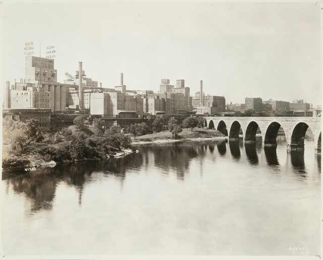 Minneapolis milling district
Three places, one system
Use the buttons to move between three important locations in the chapter.

When the wheat miracle starts to wobble
The prairie-to-wheat conversion was enormously productive, but a monoculture behaves differently from the diverse ecosystem it replaced. By the end of the century, both ecological and economic limits were becoming visible.
Wheat farming did not falter because Minnesota suddenly became poor agricultural country. The system had been built around repetition: the same crop over large areas, season after season, tied to a market that rewarded volume. Declining soil nutrients, weeds, insects, crop diseases, and an oversupplied wheat market all weakened the boom. Ecological vulnerability and economic vulnerability had begun reinforcing one another, much as technology and markets had reinforced the expansion.
Farmers adapted by shifting toward other crops and more diversified systems, but the prairie itself did not simply return when the wheat era faded. Once sod had been broken, drainage altered, rail towns established, and farms consolidated, a new geography had taken hold. That is one of the quiet lessons of landscape history: a temporary economic fashion can leave a physical pattern that lasts long after the fashion has passed.
Slash and burn: when the forest becomes fuel
Northern logging reveals the chapter's central idea with frightening clarity. The same system that successfully converted trees into lumber also created a new landscape of cutover land, dry debris, and fire risk.
Railroads transformed logging for the same reason they transformed hunting and farming: they removed a geographical constraint. Timber companies no longer had to depend almost entirely upon rivers to move logs, because tracks could penetrate forests that streams did not conveniently reach. Cutting accelerated, and behind the logging front remained stumps, branches, brush, sawdust, and other slash that dried across the cutover country.
Boosters frequently imagined that farming would follow the timber frontier, but much of northern Minnesota proved less suited to agriculture than hopeful promotion had implied. Instead of forest turning neatly into farm, large areas became cutover country covered in dead wood and combustible debris.
That left a dangerous new landscape waiting for the right weather. By 1894 the region had endured severe dryness, fires were already burning, and on September 1 heat, low humidity, and strong winds met an enormous supply of dry fuel. The Great Hinckley Fire burned roughly 350,000 acres and killed at least 418 people. It was neither simply a natural disaster nor simply a human-made disaster. It was weather acting upon ecological conditions that years of logging had helped create. [source]
The catastrophe did not invent conservation, but it made old assumptions harder to defend. The following year Minnesota created a statewide fire-warden system, with Christopher Columbus Andrews becoming the state's first chief fire warden. The state was beginning to accept a new proposition: what happened after the trees were cut was also a public responsibility.
Build the Hinckley disaster
Move through the conditions one at a time. No single ingredient explains the catastrophe.
Logging begins the transformation
Timber extraction succeeds first. The same success alters what remains on the ground.
What changed, really?
By 1900 Minnesota still had forests, wildlife, prairie remnants, rivers, and farms, but the terms of engagement had changed. The Big Woods had been fragmented, prairie agriculture operated on an enormous scale, passenger pigeons were racing toward extinction, and wheat had begun to reveal some of the weaknesses of monoculture. Minneapolis had become a flour powerhouse, while northern logging had helped create cutover landscapes capable of carrying catastrophic fire.
The deepest insight is not that development was simply bad. The new economy also created farms, homes, towns, railroads, industries, food, jobs, and remarkable wealth. The more useful lesson is that people repeatedly simplified complex ecosystems because simple systems were easier to measure, own, transport, and monetize. In doing so, they often removed some of the diversity and resilience that had made older landscapes durable.
A tree had a market price. Shade did not. Wheat had a market price. Prairie resilience did not. A passenger pigeon had a market price. A sky containing passenger pigeons did not. Lumber had a market price. A forest landscape less likely to burn catastrophically did not.
Until, of course, it did.
The chain
Landscape → perception → value → technology → market → land use → ecological change → unintended consequence → new perception. Then the process begins again.
That may be the most important lesson in Minnesota environmental history. Landscapes do not merely sit beneath history like scenery painted behind a stage. They respond. The forest grows or fails to grow. Soil accumulates or loses fertility. Wildlife reproduces or does not. Fire finds fuel or does not. Human beings act, the land answers, and the answer becomes part of the next decision.
Sometimes the lesson arrives gently, in a field that no longer produces quite as much wheat. Sometimes it arrives as the silence left by a vanished bird. And sometimes it arrives as a wall of fire.
By the turn of the twentieth century, Minnesota had become wealthier, more connected, more productive, and vastly more transformed. The next generation would inherit all of it: the farms, mills, cities, railroads, cutover lands, depleted wildlife, and a growing suspicion that perhaps progress required instructions.
1. Why did the railroad transform market hunting even though railroads themselves did not hunt animals?
2. What does the bison example demonstrate?
3. Why is the Hinckley Fire more than a story about bad weather?
4. What connects Minnesota prairie to the rise of Minneapolis?
Glossary
- Big Woods
- A historic maple-basswood and oak hardwood forest region of south-central Minnesota, now greatly reduced by farming and development.
- Bonanza farm
- A very large, highly organized commercial farm associated especially with Red River Valley wheat production in the late nineteenth century.
- Commodity
- A standardized good that can be bought, sold, and moved through large markets.
- Cutover land
- Land left after intensive logging, often containing stumps, brush, branches, and other debris.
- Ecological inheritance
- Useful ecological conditions created by earlier organisms and processes, such as fertile soil built by centuries of prairie growth.
- Economic radius
- The distance over which an activity can profitably connect to customers, suppliers, or markets.
- Ecosystem engineer
- A species whose behavior physically changes habitat and therefore affects many other organisms.
- Gradual-reduction milling
- A flour-milling method using repeated roller and sifting stages rather than one coarse grinding step.
- Market hunting
- Hunting wildlife primarily for commercial sale.
- Middlings purifier
- A machine that helped separate bran and coarse material from wheat particles, improving flour made from hard spring wheat.
- Monoculture
- An agricultural system dominated by a single crop or a very narrow range of crops.
- Natural capital
- Soils, water, organisms, and ecological processes that provide continuing benefits and productive capacity.
- Passenger pigeon
- A once-abundant migratory pigeon that became extinct in 1914 after rapid decline associated with hunting and habitat loss.
- Resilience
- The capacity of a system to absorb disturbance, reorganize, and continue functioning.
- Slash
- Woody debris left after logging, including branches, tops, and brush that can become a major fire fuel.
Works cited & further reading
Foundational works for the Minnesota reader
- Hart, John Fraser, and Susy S. Ziegler. Landscapes of Minnesota: A Geography. Minnesota Historical Society Press, 2008.
- Twin Cities Public Television and Bell Museum of Natural History. Minnesota: A History of the Land, Episode II, “Changes in the Land: 1870s–1900.” 2005. The accompanying teachers’ and viewers’ guides were used extensively in shaping this reading.
- Tester, John R. Minnesota’s Natural Heritage: An Ecological Perspective. University of Minnesota Press, 1995.
Sources used and updates for this reading
- Minnesota Department of Natural Resources. “Big Woods Subsection” and native plant-community materials. DNR Big Woods overview.
- Minnesota Department of Natural Resources. “Natural History” and “Prairie Wildlife.” These sources describe fire, grazing, bison wallowing, roaming, and the role of bison as ecosystem engineers. Prairie natural history; Prairie wildlife.
- Smithsonian Institution. “The Last Passenger Pigeon.” Updated 2026. The Smithsonian summarizes the species’ decline from billions to extinction and records Martha’s death on September 1, 1914. Smithsonian collection story.
- Minnesota Historical Society. “Minneapolis Flour Milling Boom,” “Milling Changes Farming,” and the Mill City Museum timeline. Flour-milling history; Forests, Fields, and the Falls.
- Minnesota Historical Society. “Bonanza Farms” in Forests, Fields, and the Falls. Bonanza farms.
- Minnesota Department of Natural Resources. “The Great Hinckley Fire-1894” and “Township Fire Wardens: How It All Began.” Great Hinckley Fire; Fire wardens.
- Minnesota Geospatial Information Office and Minnesota: A History of the Land reference maps. The 2000 land-use map is retained as a dated historical snapshot for comparison with earlier ecological geography.
Visual sources
- Historical biome comparison: Minnesota Terrestrial Biomes, Wikimedia Commons, based on presettlement vegetation data derived from Public Land Survey records.
- Land Use in Minnesota 2000: map from Minnesota: A History of the Land guide, colorized for instructional readability while preserving the original categories and boundaries.
- Bison photograph: Minnesota Department of Natural Resources.
- Bonanza-farm and Minneapolis milling photographs: Minnesota Historical Society collections.
- Locator map: Wikimedia Commons county-outline map. Interactive sequence diagrams are original explanatory teaching graphics, not quantitative simulations.
Historical sources sometimes use language and categories that differ from current scholarship. This reading preserves their useful evidence while using current terminology and agency or museum sources for factual verification where practical.
Looking ahead: conservation enters the argument
The twentieth century begins with a new question. If Minnesotans are powerful enough to transform a landscape, can institutions learn from consequences quickly enough to manage what happens next?


Comments
Post a Comment