1.2 Minnesota: A Pollen Grain, a Prairie Fire, and a Surveyor’s Chain
Stone, Ice,
Air, and Water
The physical geography of Minnesota—and why a farmer, a well driller, a canoeist, and a city planner all need to know what happened before they arrived.
By the end of this reading, you should be able to…
- Connect Minnesota's regional landscapes to bedrock, ice, and meltwater.
- Distinguish till, outwash, lake sediments, and loess—and explain why the differences matter.
- Trace water toward Minnesota's three continental drainage destinations.
- Explain how groundwater, climate, and land use connect places above and below the surface.
- Use physical geography to explain opportunities and constraints without treating it as destiny.
A farmer in the Red River Valley can drive across the bottom of a vanished lake without getting the tractor wet. Near Ely, a canoeist can paddle through depressions scraped into ancient rock. In southeastern Minnesota, rain can disappear underground and turn up again in a spring.
These are not three unrelated Minnesota curiosities. They are three ways of asking the same question: what kind of place is this, and how did it become that way?
The previous reading followed people turning landscapes into homelands, trade routes, property, and industrial power. Now we look beneath those decisions. Rock controls what water can cut. Ice rearranges the rock and sediment. Soil develops in what remains. Climate supplies the energy and water. A road, a crop, or a town enters a set of relationships already in motion.
You can see the consequences from a car window, provided you know which questions to ask. Why are the fields so flat here? Why do lakes suddenly become common? Why does the road climb a ridge and then descend into sand? Why does a summer afternoon become chilly as you approach Lake Superior?
The rock beneath the road
Start with bedrock. Much of Minnesota conceals it beneath sediment, but river valleys, quarries, and the North Shore offer places where the older story reaches the surface.
In the northeast, igneous and metamorphic rocks record ancient volcanic activity, intrusions, deformation, and erosion. About 1.1 billion years ago, the continent began pulling apart along the Midcontinent Rift. Lava flows and magma that cooled underground helped produce rocks now exposed around Lake Superior. The rift stopped before it split the continent; its structure remained available for much later erosion and glacial excavation. Today's lake basin is the result of that long history, not an empty chamber left when magma drained away. National Park Service.

Northern Minnesota also contains ancient sedimentary iron formations. On the Mesabi Range, these rocks concentrate iron in a particular geological belt. That helps explain why an industrial landscape developed there instead of at any convenient point on a railroad. Rock supplied the resource; extraction, processing, transportation, and demand determined how people used it. The Iron Range is another warning against treating all northern bedrock as one kind of rock. Minnesota Geological Survey: mineral resources.
Travel southeast and the story changes. Sandstone, shale, limestone, and dolostone record ancient sedimentary environments, including shallow seas. Rivers have cut through these layers to make bluff country. The contrast between a resistant layer and a weaker one can shape a cliff, a waterfall, or the course of a valley. Around the Twin Cities, the St. Peter Sandstone and overlying Platteville Formation make that relationship especially visible. Twin Cities geology.
Old rock also emerges in the Minnesota River valley and on the Sioux Quartzite ridge at Jeffers. Such outcrops remind us that southern Minnesota is not simply a deep box of soil. The soil is a relatively thin, uneven cover over a much older structure. At Jeffers, that structure is also a place of enduring Indigenous cultural significance.

The ice did not leave the furniture where it found it
A glacier moves under its own weight. As ice flows, it can quarry pieces of rock, abrade surfaces with debris held at its base, carry sediment, and deposit material far from its source. A stone in a Minnesota field may therefore tell you more about the route of an ice lobe than about the bedrock directly underneath it.
The ice sheet crossed Minnesota in different lobes, at different times, from different directions. The Rainy, Superior, Wadena, and Des Moines lobes are useful names for parts of that complicated history. Their deposits overlap. A map showing several lobes is usually a summary of events, not a photograph of one moment.
Some northern landscapes expose rock that ice scoured; elsewhere, thick deposits bury older terrain. The southeastern bluff country was outside the most recent ice advances. That does not make all southeastern Minnesota a place with no glacial history: older deposits and the boundaries of the Driftless Area require more careful distinctions.
The material matters as much as the shape. till is deposited directly by ice and mixes particle sizes. outwash is deposited by meltwater, which sorts sediment as it flows. A moraine can mark an accumulation of debris along a former ice margin. A kettle forms when a stranded block of ice melts and leaves a depression. These different histories create different drainage, construction, and farming conditions. Minnesota Geological Survey.
Read a landform as a clue
Choose the evidence. What process would produce it?

A missing lake explains two very different valleys
The Red River Valley is unusually flat because much of it was the floor of glacial Lake Agassiz. Fine sediment settled through lake water; waves also built beaches along former shorelines. The result was a broad plain interrupted by low beach ridges. When people later called this region a valley, they gave a misleadingly mountainous name to an old lake bottom.
Lake Agassiz existed because meltwater accumulated against retreating ice and surrounding terrain. As the ice changed, its outlets changed too. During intervals when it drained south, water escaped through the outlet near Browns Valley into glacial River Warren. That enormous flow helped excavate the valley occupied by today's Minnesota River. The modern river looks too small for its valley because a much larger river did much of the work. Minnesota River Basin Data Center.
Follow the consequences. Lake sediments helped create agricultural land in the northwest, but the region's low relief also makes drainage and flooding central concerns. River Warren cut a deep corridor through southern Minnesota, exposing rock, shaping tributary valleys, and creating a route that later people would use. One vanished water system left both an exceptionally flat plain and an impressively large trench.

The waterfall that helped build a city was moving
At St. Anthony Falls, relatively resistant carbonate rock overlies weaker shale and sandstone. Water erodes the weaker material, undermining the caprock. Pieces collapse, and the lip of the waterfall retreats upstream. The falls' location was therefore a stage in a process, not a permanent address.
The larger postglacial waterfall system developed as meltwater cut the river valleys. A branch retreated up the Mississippi toward the site of Minneapolis. Much later, mills concentrated around the available drop in water level. Industrial development made the falls economically valuable—and made their continued retreat a threat. Stabilization works beginning in the nineteenth century helped hold them in place. National Park Service history.
This is the physical foundation of a connection we will revisit: rock layers and glacial meltwater created a site for power; transportation, investment, labor, and technology made that site a milling center. A waterfall made one opportunity possible. It did not decide who would own the mills or receive the profits.

Soil is where the old landscape becomes a living one
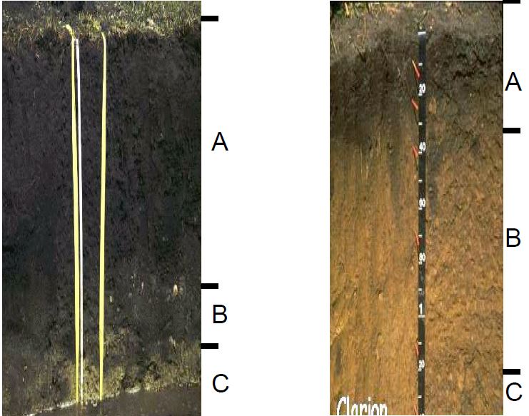
Two fields can receive the same rain and behave differently. One stays wet; another becomes dry quickly. The explanation may begin with parent material: till, outwash, lake sediment, windblown silt, or organic deposits. But parent material is only a beginning. Climate, organisms, topography, and time help turn that material into soil.
Sand and gravel commonly transmit water readily; fine-textured materials can hold more water but may drain slowly. Soil structure, compaction, slope, and depth to groundwater can change that simple comparison. A sandy soil is not automatically a bad soil, and a dark soil is not automatically protected from erosion.
loess adds another piece of the story. Wind carried silt from exposed sediment and deposited it across parts of Minnesota, particularly in the southeast and southwest. Silt-rich soils can be productive, but bare sloping surfaces are vulnerable to erosion. Vegetation, residue, and management influence how much of that inherited material stays on the field. University of Minnesota Extension.
Soil is also a record of living activity. Roots, decomposition, burrowing organisms, and water movement change its structure and chemistry. Some Minnesota soils developed under prairie; others under forest or in waterlogged settings. These influences are important without drawing a rigid boundary around every soil type. A field-scale decision needs a soil survey and observations, not just a statewide biome map.
Same rain. Different ground.
Choose a landscape and follow the water into a practical decision.
Water does not recognize the state line
A watershed is defined by where water goes. A drainage divide separates surface flow toward different outlets. The divide may be a conspicuous ridge or a rise so slight that a driver barely notices it.
Minnesota sends water toward three continental destinations: Hudson Bay, the Atlantic through the Great Lakes and St. Lawrence system, and the Gulf of Mexico through the Mississippi system. The Red River and the Rainy River belong to the Hudson Bay drainage, but they are different river systems. Rainy Lake water passes through the Rainy River, Lake of the Woods, and the Winnipeg River before joining Lake Winnipeg and the Nelson River route to Hudson Bay. International Joint Commission.
On the other side of the northern divide, streams can reach Lake Superior. Across much of central and southern Minnesota, water reaches the Mississippi, directly or through tributaries such as the Minnesota and St. Croix. In the southwest, some water takes the longer route through the Missouri River before joining the Mississippi. Naming the final destination and naming the immediate river basin are different levels of description.
A watershed map is therefore a map of relationships. A drainage ditch, a paved parking lot, or a restored wetland can change the timing and quality of water downstream. The consequences do not stop at the edge of the property that produced them. Explore the Minnesota DNR’s watershed poster and basin map.
Give a raindrop an address
Choose a starting place. Follow a representative surface-water route toward its continental destination.
The map continues underground
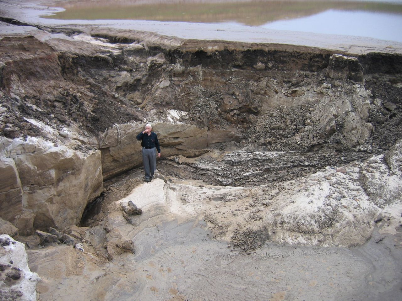
A well does not usually tap a large underground lake. Most groundwater occupies pores between grains or fractures in rock. An aquifer stores and transmits enough of that water to supply wells or springs. Minnesota's groundwater conditions vary with the same geology that helps explain its surface landscapes.
In sand and gravel, connected pore spaces can transmit water. In bedrock, fractures or permeable layers may provide the pathway. Water that enters the ground can move slowly or quickly depending on those pathways; crossing the soil surface does not guarantee that pollutants have been removed.
Southeastern karst makes the connection unusually visible. Water dissolves soluble carbonate rock along fractures, enlarging passages and producing features such as sinkholes, caves, and springs. Surface water can enter connected openings and move rapidly toward groundwater or streams. An underground drainage boundary may differ from the divide suggested by hills at the surface. Minnesota DNR: karst and springs.
This is why the location of a well, a sinkhole, or a manure application matters. Land use and drinking water are connected through the material between them. The later pollution readings will follow particular substances; the physical lesson comes first: know the pathway before assuming that distance provides protection.
A continental address has consequences
Minnesota's continental climate reflects its interior location and latitude. Large seasonal changes in sunlight arrive without a nearby ocean moderating most of the state. Winter brings short days and a low sun angle. Summer brings much longer days and stronger solar heating. The seasons come from Earth's tilted axis, not from Earth moving dramatically closer to the Sun in July.
Cold air can arrive from the north, while warm, moist air can move inland from the Gulf of Mexico. Passing pressure systems, fronts, and the jet stream help organize the weather. Air masses do not simply collide and guarantee a tornado: moisture, instability, lifting, and wind structure influence which storms develop.
Incoming sunlight is partly reflected and partly absorbed by the surface and atmosphere. The warmed surface transfers energy to the air through several processes and emits infrared radiation. Greenhouse gases absorb and emit some of that infrared energy. They are not a layer of insulation created by snow. Snow instead has a high albedo: it reflects much of the incoming sunlight. These are different processes with different effects.
Local conditions sharpen the contrasts. On clear, calm nights, cold dense air can collect in low places. The official Minnesota record of −60°F was measured near Tower on February 2, 1996. That single observation describes an extreme; it is not a normal winter temperature. Minnesota DNR record.
Cities introduce another local influence. Pavement and buildings change heat storage, shade, airflow, and evaporation. Urban areas can remain warmer than surrounding rural land, particularly at night. That matters for summer heat exposure as well as winter temperature comparisons.
Lake Superior keeps its own calendar
Water stores considerable heat, mixes vertically, and changes temperature more slowly than the land around it. Lake Superior can keep nearby air cooler during spring and summer and moderate cold during autumn and winter. The effect depends on wind direction, proximity to the shore, and ice conditions. Duluth's hilltop and lakeshore need not experience the same afternoon.
Cold air moving across open lake water can also pick up heat and moisture. Under suitable wind and temperature conditions, that moisture contributes to lake-effect snow. Moderation of temperature and enhancement of snowfall are compatible: a place can be less bitterly cold because of a lake and still receive additional snow. DNR: North Shore Highlands.

Let the lake take its time
Change the season to compare the shore with nearby inland locations.
A wet year can still contain a drought
Minnesota generally becomes warmer toward the south, and annual precipitation generally increases from the northwest toward the southeast. These are broad gradients, modified by elevation, lakes, and the paths of storms. They help explain differences in growing-season length and water availability, but crop choice also depends on soil, drainage, seed varieties, markets, and technology.
The amount of precipitation is only part of a water budget. Some water runs off, some enters storage, and some returns to the atmosphere through evapotranspiration. An intense storm may produce flooding while doing less for a crop than several smaller, well-timed rains. Warm conditions can increase water demand, so a wetter annual total does not rule out damaging dry spells.
Timing also changes hazards. Snowmelt can arrive while soils are frozen or already wet. Water spreading across the low-relief Red River plain behaves differently from runoff concentrating rapidly in steep southeastern valleys. A flood is therefore more than a large quantity of water: it is water interacting with the shape and condition of a particular landscape.
The averages are moving too
A climate normal summarizes a standard thirty-year period. It gives us a reference for comparison; it is not a promise that next July will look like the average July. Maps and tables should identify their reference period because the baseline changes.
The University of Minnesota Climate Adaptation Partnership reports that statewide annual average temperature increased about 3.4°F from 1895 through 2025, with particularly strong warming in winter and in overnight lows. Minnesota has also experienced heavier precipitation events. Those observations help explain why infrastructure, agriculture, winter recreation, and water management face changing conditions. UMN Climate Adaptation Partnership, 2026.
Human-caused greenhouse-gas increases are driving the current global warming trend; natural variability still influences individual seasons and years. A cold week can occur within a warming climate, just as a wet year can contain a dry summer. Confusing the timescales makes both patterns harder to understand. NASA: causes of climate change.
Four processes, one Minnesota
Return to the farmer, the canoeist, and the spring. Their landscapes differ because the history and arrangement of rock, sediment, water, and climate differ. Those differences help explain where people can grow crops, drill wells, build roads, generate power, or reach a lake.
They create possibilities and constraints, not a complete social script. The same land can support different practices under different technologies, ownership systems, values, and public decisions. Physical geography explains why choices have consequences; it does not make the choices for us.
Next, we follow what happened when Minnesota's forests, wildlife, and prairie soils became resources in an expanding industrial economy. Then Reading 2.2 asks how the living communities themselves assemble and change. By that point, the familiar biome map will rest on something more useful than memorized colors: an understanding of the ground, water, and climate beneath it.
Carry these connections forward
- Rock to landform: resistance, fractures, and layering influence erosion, valleys, and groundwater.
- Ice to sediment: different transport and deposition processes leave different surfaces.
- Sediment to land use: soil development and drainage affect farming and construction.
- Watershed to responsibility: actions in one place can change water elsewhere.
- Climate to decisions: seasonal patterns, extremes, and long-term trends all matter.
Questions for geographic thinking
- Why could both a flat landscape and a steep landscape create flood problems? Compare their pathways.
- A farm and a subdivision occupy similar sandy ground. Which water-related opportunities and risks might they share?
- How did a process that made St. Anthony Falls useful also threaten the industries built around it?
- What additional evidence would you want before choosing a location for a new well in southeastern Minnesota?
- Choose one Minnesota economic activity and trace its physical foundations without claiming that the environment determines its outcome.
Key vocabulary
- Bedrock
- The solid rock beneath soil and other loose surface deposits.
- Till
- A mixture of sediment sizes deposited directly by glacial ice.
- Outwash
- Sediment sorted and deposited by flowing glacial meltwater.
- Moraine
- An accumulation of glacial debris, often expressed as a ridge or belt of hills.
- Kettle
- A depression left when a buried or partly buried block of ice melts.
- Loess
- Wind-deposited sediment composed mainly of silt.
- Watershed
- The land area whose surface water drains to a common outlet.
- Aquifer
- Rock or sediment that stores and transmits enough groundwater to supply wells or springs.
- Karst
- A landscape with dissolution features such as sinkholes, caves, and connected underground drainage.
- Continental climate
- A climate with large seasonal temperature differences associated with an interior continental location.
- Albedo
- The fraction of incoming sunlight that a surface reflects.
- Climate normal
- A statistic calculated for a standard 30-year period to describe a typical climate.
- Evapotranspiration
- Water transferred to the atmosphere by evaporation and by plants.
- Parent material
- The mineral or organic material from which a soil develops.
- Drainage divide
- A boundary separating land that drains toward different outlets.
Check your understanding
Choose an answer, then check the reasoning. These questions are practice for this reading.
Sources
Foundational works
- Hart, John Fraser, and Susy Svatek Ziegler. Landscapes of Minnesota: A Geography. Minnesota Historical Society Press, 2008.
- Tester, John R. Minnesota’s Natural Heritage: An Ecological Perspective. University of Minnesota Press, 1995.
- Adams, John S., and Barbara J. VanDrasek. Minneapolis–St. Paul: People, Place, and Public Life. University of Minnesota Press, 1993.
- Twin Cities Public Television and Bell Museum. Minnesota: A History of the Land. Original documentary series, 2005.
Sources used and updates
- Minnesota Geological Survey. Mining. Geological concentration of iron deposits on the Mesabi Range.
- Minnesota Geological Survey. Glacial Geology. Ice lobes, till, moraines, outwash, and glacial lakes.
- Stein and colleagues. Using Lake Superior parks to explain the Midcontinent Rift. National Park Service, 2015. The rift and the geological history of the Lake Superior region.
- National Park Service. Twin Cities Geology. Sedimentary rocks and visible river-bluff geology.
- National Park Service. River of History, Chapter 6. The retreat and stabilization of St. Anthony Falls.
- Minnesota River Basin Data Center. Water Storage: Geologic History. Lake Agassiz, glacial deposits, and River Warren.
- University of Minnesota Extension. Five Factors of Soil Formation. Parent materials, loess, soil development, and drainage.
- Minnesota DNR. Watershed Poster. Continental drainage directions and river-basin geography.
- International Joint Commission. Lake of the Woods and Rainy River. The northern drainage route through the Winnipeg and Nelson systems.
- Minnesota DNR. Springs, Springsheds, and Karst. Underground pathways and the relationship between surface water and groundwater.
- Minnesota DNR. North Shore Highlands Subsection. Lake Superior and local physical conditions.
- Minnesota DNR. Minnesota’s All-Time Record Low. The February 2, 1996 observation near Tower.
- Minnesota DNR. Climate Summaries and Publications. Climate descriptions, dated normals, and regional comparisons.
- University of Minnesota Climate Adaptation Partnership. Climate Change in Minnesota, 2026. Observed change through 2025; the dated statewide warming figure.
- NASA. The Causes of Climate Change. The greenhouse effect and human causes of recent warming.
Visual credits
All photographs, maps, and the satellite image are credited and linked to their sources in the captions. The landform cross-sections and interactive comparisons are original teaching diagrams. They illustrate mechanisms and do not represent measured site profiles or forecasts.


Comments
Post a Comment