2.2 Evolving Ecosystems The Map Won't Sit Still
The Map Won't Sit Still
Fire, forest, prairie, and the moving ecology of Minnesota. A biome map looks like a finished answer until you realize every line on it is the temporary result of climate, disturbance, migration, soil, water, and time.
Read the lines as processes
After completing this reading, you should be able to:
- Explain why Minnesota's biomes are changing assemblages rather than fixed ecological territories.
- Use fossil pollen and Public Land Survey records as evidence for past vegetation while recognizing the limits of each record.
- Explain how moisture balance, fire, soil, and topography help create prairie-forest ecotones.
- Describe how fire and succession can maintain, reorganize, or replace ecological communities.
- Evaluate competing restoration goals when historical conditions, rare species, present land use, and future climate do not point toward exactly the same landscape.
Minnesota has a peculiar habit of looking permanent.
Stand in western Minnesota and prairie seems to belong there. Stand beneath maple and basswood in the Big Woods and forest seems equally inevitable. Drive north past Duluth into spruce, pine, bog, and exposed rock and it becomes difficult to imagine the place being anything else. Yet all three impressions are misleading, not because those landscapes are unreal, but because they are temporary.
The ecological map of Minnesota has never sat still. When the last glaciers retreated from northern Minnesota, much of the newly exposed surface had little developed soil and almost no vegetation. Plants had to colonize it. Trees had to return. Prairie had to expand. Species arrived at different speeds, responded differently to warming and drying, and repeatedly rearranged the communities we now draw as tidy colored regions on maps. Paleoecological evidence makes the deeper point clear: Minnesota's ecosystems evolved after glaciation, and the species inside them responded individually rather than moving around as intact packages.
That is our central idea. A biome is not a permanent possession of the land. It is a temporary agreement among climate, soil, water, disturbance, and the organisms capable of living there.
Four Minnesotas meet in one state
Older historical maps often simplify Minnesota into three broad biomes. The Minnesota DNR's current educational framework recognizes four: prairie grassland, deciduous forest, coniferous forest, and tallgrass aspen parkland. The fourth is itself a transition between prairie and forest.

The useful question is not "Where is the line?" It is "Why is the line there at all?"
The ecosystem does not own a moving van
When climate changes, a forest does not pack itself into a truck and head north. Individual species move, survive, fail, and reproduce at different rates. The biome is what we call the community that eventually emerges from those separate responses.
That difference matters. Aspen produces light seeds that can travel on the wind. Oaks produce acorns that mostly fall near their parent tree unless an animal carries them farther. Spruce, pine, prairie grasses, mosses, lichens, shrubs, insects, birds, and mammals all respond differently to temperature, moisture, disturbance, and available soil. Postglacial recolonization took thousands of years because each species dispersed in its own way and encountered different ecological limits.
A biome therefore behaves less like an army crossing a border and more like a crowd leaving a building after the fire alarm. Everyone is moving, but not at the same speed or in quite the same direction.
Migrate!
Change the climate. Watch four kinds of plants respond differently. This is a teaching model, not a prediction map.
At moderate temperature and moisture, several communities can overlap. Change the conditions and their relative advantage changes differently.
How do we know?
Trees are inconsiderate historical witnesses. They die. Fortunately, they leave pollen everywhere, and lakes are remarkably good filing cabinets.
Pollen falls onto lakes and wetlands, settles into sediment, and gets buried under younger material. Extract a sediment core and depth becomes time. Identify the pollen in each layer and the mud begins telling us which plants were common when that layer formed. Fossil pollen records document rapid postglacial changes, including intervals when prairie expanded eastward under warmer, drier conditions and forest shifted westward as moisture increased.
This is one of those lovely scientific tricks in which something utterly ordinary becomes a time machine. Nobody had to stand in Minnesota eight thousand years ago taking vegetation notes. The lake kept the notes for us.
Drill into a lake
Choose a depth in a fictional sediment core. Each layer represents a different ecological moment.
The border is called an ecotone
Prairie and forest do not meet at a wall. They meet in a zone where small changes in moisture, fire, soil, and topography can tip the advantage from grass to trees and back again.
Historical precipitation and water-balance maps are especially useful here. Western Minnesota tends to be drier, while eastern Minnesota receives more moisture. Modern DNR ecological classifications make the same point in a slightly different language: prairie parkland and tallgrass aspen parkland commonly lose as much or more water to evapotranspiration as they receive, the eastern broadleaf forest sits near a balance, and much of the Laurentian mixed forest has a moisture surplus.
This helps explain why the broad northwest-to-southeast forest-prairie boundary exists. It is not a line somebody could have found painted on the ground in 1850. It is the visible result of a water budget interacting with fire, topography, and soils.
Move the forest
Adjust moisture and fire. The boundary responds gradually because the real landscape is a balance, not a switch.
Near the balance point, prairie, oak savanna, woodland, and forest can occur close together. Small changes matter.
The indecisive biome

Tallgrass aspen parkland
Northwestern Minnesota's smallest biome is almost a demonstration model for the whole chapter: prairie, sedge fen, aspen groves, and bur oak coexist in a transition between drier prairie to the west and wetter forest to the east.
Fire is not the opposite of nature
A blackened prairie can look ruined and a green thicket can look healthy. Ecologically, that judgment can be exactly backward.
Fire historically helped maintain Minnesota prairie by suppressing woody vegetation while deeply rooted grasses and flowering plants survived below ground and regrew. Indigenous people also used fire intentionally for landscape management and hunting. European settlement suppressed fire across large areas through cultivation, grazing, roads, and active fire control, changing the balance in fire-dependent ecosystems.
Oak savanna makes the lesson especially visible. Savanna is neither closed forest nor treeless prairie. Fire-tolerant oaks can persist while recurring fire limits shrubs and young trees. Remove fire long enough and the canopy closes. Reintroduce carefully planned prescribed fire and managers can push the system back toward a more open savanna structure.
Turn off fire
Watch an open oak savanna begin closing into woodland. Then restore fire.
Fire suppressed
Without periodic fire, shrubs and young trees gain ground. Over time the open savanna can shift toward denser woodland.
The Big Woods was not always the Big Woods
The name sounds ancient enough to have been printed on the landscape at creation. The pollen record says otherwise.
Pollen and charcoal evidence indicates that the Big Woods expanded comparatively recently in ecological time, replacing more open vegetation as conditions changed. Moisture, fire frequency, topography, seed movement, and soil all influenced where maple-basswood forest could establish. The important point is not one exact date but the larger pattern: even a forest that feels timeless is part of a moving history.
Euro-American settlement then altered that history at extraordinary speed. Much of the Big Woods was cleared for agriculture and settlement. What remain today are fragments and protected remnants rather than the former continuous forest. Human land use became one more disturbance capable of redrawing a biome boundary, only now at a speed that ecological succession could not easily match.
The surveyors accidentally became ecologists
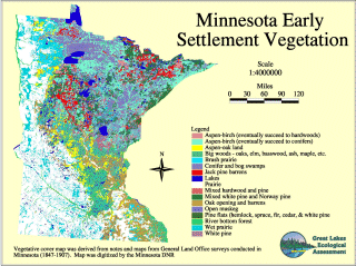
Between 1848 and 1907, Public Land Survey crews recorded bearing trees, wetlands, fires, topography, and other landscape observations while establishing Minnesota's survey grid. Francis J. Marschner later interpreted General Land Office records to reconstruct vegetation at the time of Euro-American settlement.
There are species for which Minnesota is the whole map
One small flower turns the abstract word biodiversity into something rather less abstract.
The Minnesota dwarf trout lily, also called the Minnesota fawnlily, occurs naturally only in a small part of southeastern Minnesota. The U.S. Fish and Wildlife Service currently lists it as endangered and describes it as a Minnesota endemic: a species found naturally in Minnesota and nowhere else on Earth. It is known from Goodhue, Rice, and Steele counties, especially in rich maple-basswood slopes, ravines, and adjoining floodplains.
The plant remains federally endangered, but it is not Minnesota's only federally listed species. The ecological point is more important than the old superlative: a species with a tiny geographic range has very little room for error.

If this plant disappears from southeastern Minnesota, it does not survive in another state. Its known natural world is concentrated here.
Up north, fire builds a forest too
The fire story becomes stranger in the coniferous north. Fire kills trees, but disturbance can also create the conditions that favor the next forest.
Northern Minnesota forests have long been rearranged by wildfire, wind, insects, and disease. Fire-dependent pine communities developed within that disturbance regime, and species such as jack pine possess adaptations that help them reproduce after fire. Old-growth red and white pine forests became rare largely because nineteenth- and early twentieth-century logging removed so much of the former tall-pine landscape.
Protected places such as Itasca Wilderness Sanctuary preserve fragments of those older forests. The DNR identifies hundreds of acres of designated old growth at the site, including stands with red and white pines roughly two centuries old. A forest like this looks timeless precisely because human lifetimes are short.

Old growth at Itasca
Old growth is not simply "a lot of big trees." It is a late stage of forest development containing structures and relationships accumulated over long spans of time.
Succession: nature never says "done"
Disturbance does not simply damage an ecosystem. It changes the conditions, and different organisms become favored under the new arrangement.
Ecologists call this shifting sequence succession. After fire in a deciduous forest, grasses and other nonwoody pioneers may arrive first, followed by shrubs, sun-loving young trees, and eventually more shade-tolerant species such as maple and basswood. Minnesota DNR notes that such a sequence can unfold over hundreds of years and can be interrupted at any point by another fire, windstorm, disease outbreak, or other disturbance.
The crucial point is that succession is not nature repairing itself to factory settings. Conditions continue to change. The organisms are not the same individuals. New disturbances arrive. Climate shifts. Human beings intervene. Nature does not rewind. Nature continues.
Press disturbance
Step through a simplified deciduous-forest succession sequence.

So what exactly are we restoring?
Suppose we decide to restore Minnesota's natural landscape. An admirable idea. There is only one small problem: which Minnesota?
The restoration question is unavoidable. Conservationists often use the nineteenth-century landscape as a reference because Public Land Survey records give unusually detailed evidence for it. But why privilege 1850? Why not the Big Woods of a few centuries earlier, the warmer and drier landscape of eight thousand years ago, the postglacial tundra-like landscape, or a future ecosystem better adapted to the climate of the next century?
There was never one untouched Minnesota frozen in ecological perfection. Indigenous people used fire and other practices that influenced ecosystems long before Euro-American settlement. Climate changed. Species migrated. Fires burned. Windstorms tore forests open. Beavers flooded valleys. Bison altered prairie. Then agriculture, logging, urbanization, invasive species, pollution, and modern climate change added still more forces.
That does not make conservation meaningless. It makes conservation a choice. Are we conserving species, ecological processes, historic communities, rare habitats, resilience, beauty, future adaptability, or some mixture of all of them? Those goals often overlap. They are not identical.
Pick your Minnesota
Choose a reference point for restoration. Every choice solves one problem and creates another.
The map won't sit still
We like maps because they hold the world still long enough for us to understand it. That is their power, and occasionally their deception. A biome map freezes one arrangement of climate, water, soils, disturbance, plants, animals, and people and gives the impression that the arrangement itself is the landscape.
It is not. The lines are consequences. Change the temperature, precipitation, fire regime, species pool, drainage, or human land use and the lines begin to move. Sometimes that happens over thousands of years. Sometimes, as Minnesota learned after Euro-American settlement, it can happen in a few generations.
That is why this subject sits between physical geography and Minnesota's human history. Stone, ice, air, and water built the stage, but the living scenery never stops rearranging itself. The next reading follows people moving through that shifting landscape with canoes, trade goods, treaties, carts, and eventually an entirely new political map.
1. Why is it misleading to imagine an entire biome simply "moving" when climate changes?
2. What can fossil pollen in lake sediments tell us?
3. Why can suppressing fire change a prairie or oak savanna?
4. Why is the Minnesota dwarf trout lily especially vulnerable?
5. What is the central restoration problem raised at the end of the reading?
Glossary
- Biome
- A broad ecological region shaped by climate and characterized by recurring communities of plants and animals.
- Postglacial recolonization
- The spread and re-establishment of organisms after glacial ice retreated.
- Dispersal
- The movement or spread of organisms, seeds, spores, or propagules into new areas.
- Fossil pollen
- Pollen preserved in sediment and used to reconstruct past vegetation and environmental conditions.
- Ecotone
- A transition zone where neighboring ecological communities overlap and intermingle.
- Evapotranspiration
- Water transferred to the atmosphere through evaporation and plant transpiration.
- Water budget
- The balance among precipitation, runoff, storage, evaporation, and plant water use.
- Oak savanna
- An open prairie-like community with scattered fire-tolerant oaks, historically maintained by recurring disturbance.
- Prescribed fire
- A planned and carefully managed burn used to meet ecological or land-management objectives.
- Public Land Survey
- The federal rectangular survey system whose field notes also preserve historical observations of vegetation and landscape conditions.
- Bearing tree
- A tree identified by a surveyor to help mark and relocate a survey corner.
- Endemic
- Native to and naturally restricted to a particular geographic area.
- Biodiversity
- The variety of genes, species, ecological communities, and relationships within a place.
- Old-growth forest
- A long-developed forest with old trees, structural complexity, canopy gaps, and accumulated dead wood.
- Succession
- The changing sequence of species and community structure after disturbance or through time.
- Disturbance
- An event such as fire, wind, flood, grazing, insects, disease, or human activity that changes ecosystem conditions.
- Restoration ecology
- The science and practice of assisting the recovery of degraded ecosystems while choosing goals and reference conditions.
- Resilience
- The capacity of an ecological system to absorb disturbance, reorganize, and continue functioning.
Works cited & further reading
Foundational works for the Minnesota reader
- Hart, John Fraser, and Susy Svatek Ziegler. Landscapes of Minnesota: A Geography. Minnesota Historical Society Press, 2008.
- Tester, John R. Minnesota's Natural Heritage: An Ecological Perspective. University of Minnesota Press, 1995.
- Twin Cities Public Television and Bell Museum of Natural History. Minnesota: A History of the Land. 2005.
- Adams, John S., and Barbara J. VanDrasek. Minneapolis-St. Paul: People, Place, and Public Life. University of Minnesota Press, 1993.
Sources used and updates for this reading
- Minnesota Department of Natural Resources. "Biomes of Minnesota Poster" and biome teaching materials. Current DNR materials.
- Minnesota Department of Natural Resources. "Prairie Grasslands Biome" and "Tallgrass Aspen Parkland Biome." Prairie; Tallgrass aspen parkland.
- Minnesota Geospatial Information Office. "Minnesota Land Use/Cover: Historic." Includes General Land Office bearing-tree records, fossil-pollen reconstructions, and Francis J. Marschner's original-vegetation map. MnGeo historic land cover.
- Minnesota Geospatial Information Office. "Original Public Land Survey Plats of Minnesota." The original plat collection contains more than 3,600 maps created between 1848 and 1907. MnGeo PLSS collection.
- U.S. Fish and Wildlife Service. "Minnesota Fawnlily (Erythronium propullans)." The federally endangered plant is a Minnesota endemic known from Goodhue, Rice, and Steele counties. Species profile.
- Minnesota Department of Natural Resources. "Visit an Old-Growth Forest" and "Characteristics of Old Growth." Itasca Wilderness Sanctuary SNA contains 848 acres of designated old growth in 16 stands; DNR inventories document red and white pine stands roughly two centuries old. Old-growth sites.
- Minnesota Department of Natural Resources. Native Plant Community Classification and ecological-province field guides. DNR classification.
Visual sources
- Minnesota DNR: biome map, tallgrass aspen parkland, old-growth Itasca imagery, and succession diagram.
- Minnesota Geospatial Information Office: historical vegetation / Marschner mapping.
- U.S. Fish and Wildlife Service: Minnesota fawnlily photograph.
Next: The Highway Was Made of Water
Once we know that Minnesota's ecosystems are moving systems rather than static backdrops, human history looks different. People do not enter an empty stage. They move through, depend upon, manage, trade within, and eventually transform living landscapes already in motion.


Comments
Post a Comment