3.1 Movement, Trade, and Sovereignty The Highway Was Made of Water
The Highway Was Made of Water
Canoes, beaver hats, portages, treaties, and the long geography of sovereignty. Before Minnesota had a highway system, people were already moving through a transportation network shaped by rivers, lakes, seasons, and knowledge.
Before Minnesota had highways, it had highways. They were just rather wet.
Long before anyone painted a white line down the middle of a road, the country that would become Minnesota contained an elaborate transportation system. Rivers joined lakes, trails connected rivers that did not quite meet, and short stretches of land became portages. Seasonal camps linked maple groves, fishing places, gardens, wild-rice lakes, hunting grounds, and winter shelter. Europeans did not arrive in a landscape without routes. They entered a landscape whose routes were already known.
Dakota communities moved through southern and central Minnesota according to a seasonal geography. Winter brought sheltered camps and hunting. Spring brought maple sugaring, fishing, trapping, and waterfowl. During the growing season, communities returned to places where corn, beans, squash, and other crops could be cultivated while hunting, fishing, gathering, ceremony, and social life continued. In autumn, some communities harvested wild rice and prepared for the large hunt and the coming winter. The important thing is that people returned to known places. Mobility required memory, timing, and intimate geographical knowledge.
Anishinaabe communities likewise developed relationships with lakes, forests, fisheries, rice lakes, sugar bushes, hunting territories, and travel corridors in northern Minnesota. Their westward movement brought trade, alliance, intermarriage, and conflict with Dakota communities across different periods. The old summary reduces some of this to one people pushing another westward, but the real geography was more complicated and more human than a single arrow on a map.
The year is a map
Choose a season. The useful geography of the same landscape changes with the calendar.
Sheltered woodland camps, stored foods, and large-game hunting become especially important when lakes freeze and snow covers the ground.
The machine made from a forest
Now suppose you need a boat. It must cross a large lake, enter a narrow river, carry people and cargo, survive rocky water, and still be light enough to carry when the river becomes a waterfall. Better yet, if it breaks, the repair shop should be growing beside you.
The birchbark canoe meets that specification beautifully. Birch bark forms the skin. Cedar supplies structural pieces and ribs. Spruce root can become lashing. Spruce pitch seals seams. The result is light enough to portage yet capable of carrying substantial loads through northern waterways. European traders adopted this Indigenous technology because it was already adapted to the landscape they were trying to enter.
That reverses an old assumption about technological history. The newcomers did not bring the superior transportation technology into Minnesota. For this landscape, they borrowed it. Once you notice that, a canoe stops being a picturesque object in a museum and becomes something much more interesting: a piece of applied geography.
Build a canoe from the forest
Add the materials one by one. Then launch the finished craft.

A boat built from the boreal forest
The canoe works because its materials are local, light, flexible, and repairable. The technology converts birch, cedar, spruce root, and pitch into a transportation system.
Somewhere in Europe, somebody wants a hat
Imagine a beaver in a Minnesota wetland doing perfectly ordinary beaver things. Thousands of miles away, somebody decides that beaver felt looks splendid on a hat. The two facts meet, and Minnesota enters a distant market.
European demand made beaver pelts valuable, while Dakota, Anishinaabe, and other Indigenous traders wanted manufactured goods that Europeans could supply, including metal tools, cloth, kettles, and firearms. Early fur trading therefore depended upon exchange, but it depended especially upon Indigenous hunting, transportation knowledge, food systems, and existing trade networks.
The French did not arrive with a blank map and invent where traffic would go. They learned routes. They obtained food. They depended on people who already knew where one could travel, where one had to portage, and how to survive when January arrived, as it does with a certain consistency around here. What Europeans supplied was something different: an expanding market whose demand originated far beyond the landscape where the animals lived.
A Minnesota beaver was still ecologically a beaver. Economically, it had become inventory.
Follow the hat
Click along the chain. The fur trade happens in every place the commodity passes through.
The road map is blue
A modern highway map emphasizes asphalt. The older transportation map was blue. Rivers, lakes, and portages decided which directions were cheap and which ones required somebody to get out and carry the boat.
The source reading identifies five principal corridors into Minnesota: south from Hudson Bay through the Red River country; west from Grand Portage through the Pigeon and Rainy systems toward Lake of the Woods; inland from Fond du Lac and the St. Louis River toward the Mississippi headwaters; from the Brule to the St. Croix; and from Green Bay through the Fox-Wisconsin system to Prairie du Chien and then north on the Mississippi. These are not merely arrows across empty space. They are routes created by physical geography.
Four ways out of Minnesota
Minnesota occupies a continental watershed junction. Follow the rivers far enough and the water reaches Hudson Bay, the Atlantic Ocean, or the Gulf of Mexico by two different river systems.

Five ways into Minnesota
Turn on the major fur-trade corridors one at a time.
The men carrying ninety pounds through the woods
Minnesota memory has been rather kind to the voyageurs. Colorful sashes, paddling songs, picturesque canoes. The employment brochure seems to have misplaced the part about enormous bales and mosquitoes.
Voyageurs supplied much of the human transportation power of the fur-trade system. National Park Service materials distinguish the seasonal Montrealers from the North Men or winterers who worked farther in the interior. The Montreal-to-Grand-Portage run stretched roughly 1,200 miles and took about six weeks to two months. At the rendezvous, voyageurs also hauled trade goods and furs over the Grand Portage trail.
The old reading describes ninety-pound bales and men sometimes carrying two. Using those source figures, that is roughly 180 pounds moving through a forest by muscle alone. National Park Service research places the typical two-piece portage load more broadly at about 160 to 200 pounds.
The transportation network therefore ran on three things at once: physical geography, Indigenous technology, and human labor.
What did a portage load actually look like?
Move between one freight piece and the typical two-piece load described in historical accounts.
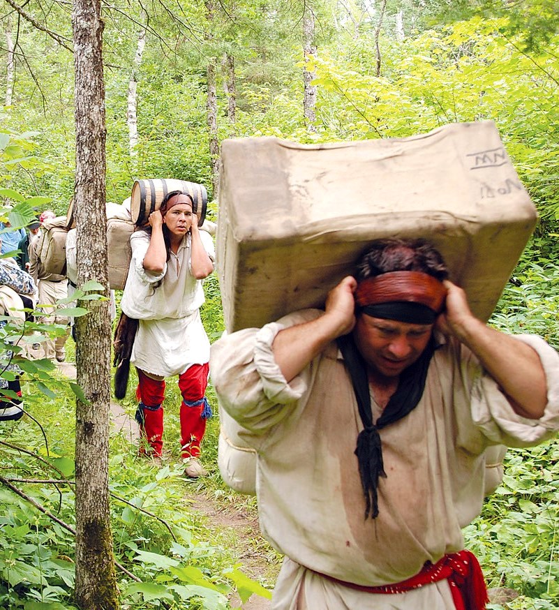
The chapter source describes trade bales of about ninety pounds. Even one piece makes the physical labor of the fur trade suddenly less romantic.

The network had a workforce
Waterways explain where trade could move cheaply. Canoes explain how. Voyageurs explain who supplied much of the muscle.
Grand Portage: the middle of nowhere, except for everyone
Grand Portage seems remote today because we are looking at Minnesota with roads in our heads. On a map organized around canoe travel, Gichi Onigaming occupies a magnificent location.
The Grand Portage trail bypasses falls, rapids, and gorges on the Pigeon River and links Lake Superior to waterways leading into the continental interior. Indigenous travelers used this route long before European fur companies adopted it. In the later eighteenth century, the North West Company developed Grand Portage into a major summer headquarters and rendezvous.
Trade goods arriving from Montreal were broken down for the interior. Furs arriving from distant winter posts were prepared for the eastward journey. Canoes were built and repaired. Accounts were settled. Hundreds of people who had spent months scattered across an enormous territory met in one place.
Location is not an intrinsic property. Grand Portage did not become more remote when the fur trade declined. The transportation system around it changed.

An eighteenth-century logistics hub
Grand Portage was not a picturesque cabin at the edge of the world. It was a transshipment center where Lake Superior traffic met the interior water network.
How a place becomes remote
Move between two transportation systems. Grand Portage stays in the same place while its relative importance changes.
In the water-and-portage network, Grand Portage sits at a critical transfer point between Lake Superior and the continental interior.
Winter posts: commerce at the edge of the map
Grand Portage was the hub, but much of the actual exchange happened at smaller posts built along lakes and rivers near Indigenous communities and food sources.
The source reading notes that historian Grace Lee Nute identified more than 150 trading-post locations in Minnesota, with many more likely lost or undiscovered. The reconstructed fur post near Pine City offers a useful example of an interior post whose location depended on river travel, access to fish, proximity to Ojibwe winter camps, and the ability to obtain wild rice, maple sugar, meat, and other necessities.
This is also where the old picture of Europeans and Indigenous people as two separate populations passing objects across a counter becomes inadequate. European and Métis traders formed families with Indigenous women. Kinship, language, food knowledge, material skills, and social relationships could be central to trading households. Trade did not merely move commodities. It created communities.
Then the canoe grows wheels
The Red River cart is almost aggressively straightforward: two enormous wooden wheels, a wooden axle, a box, and an animal to pull it. The design is simple. The sound was not.
Métis traders used Red River carts to move goods, hides, and supplies between the Red River settlements and markets farther south, including St. Paul. The carts' wooden axles were famously loud enough that a train could announce itself before it arrived.
The water network had acquired an overland branch. Roads in the modern sense still did not exist across much of the region, but repeated cart traffic carved recognizable routes into the prairie. Eventually steamboats and railroads would change the transportation system again.

The canoe acquires an overland branch
Red River carts loading at a St. Paul trading house in 1854. Métis cart traffic linked the Red River world with Minnesota markets.
Optional sound: hear the squeal of a replica Red River cart.
When the canoe gets wheels
These three major trail families connected the Red River region with Fort Snelling and St. Paul.
The center moves again
American power enters this geography through the Mississippi. Fort Snelling rises at Bdote, the confluence of the Minnesota and Mississippi rivers, and nearby Mendota becomes an important American fur-trade center.
The confluence had been important to Dakota people long before the fort existed. American military and commercial institutions did not create the location's importance; they added new political and economic meanings to it. By the 1820s, American Fur Company interests dominated much of the regional trade, while the fur economy itself was already beginning to change as beaver fashions waned and settlement pressure increased.
Again the rivers did not move. The political meaning of the confluence did. Dakota homeland, trade center, military post, American territorial node, and later metropolitan core occupy nearly the same coordinates.
Then the desired commodity changes. Fur traders had wanted animals. Settlers wanted land.
When fur-trade debt becomes a land cession
The fur economy tied Dakota communities and traders together through credit. Goods were advanced against future furs, accounts became disputed, and traders developed a financial interest in treaty payments. Then the commodity at the center of the relationship changed from pelts to territory.
In 1851, Dakota representatives signed the Treaties of Traverse des Sioux and Mendota. Together the treaties ceded enormous areas of southern and central Minnesota and neighboring territory. The result was a dramatic contraction of Dakota-controlled land and increasing dependence upon treaty payments and supplies.
The connection to the fur trade did not disappear when the land negotiations began. The treaty process was entangled with trader debts and payments, including the notorious Traders' Paper at Traverse des Sioux. A commercial relationship built around furs had become part of a political process transferring land.
Treaty of Traverse des Sioux
The image deserves enough space to read. The treaty is where this chapter's commodity shifts from fur to territory.
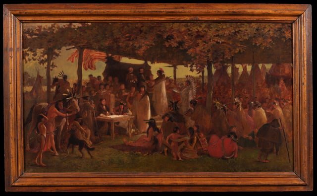
The commodity is no longer merely beaver. It is territory.
Frank Blackwell Mayer witnessed the 1851 negotiations and later painted this scene. Enlarging the image lets students see the gathering itself rather than treating it as a dark decorative sidebar.
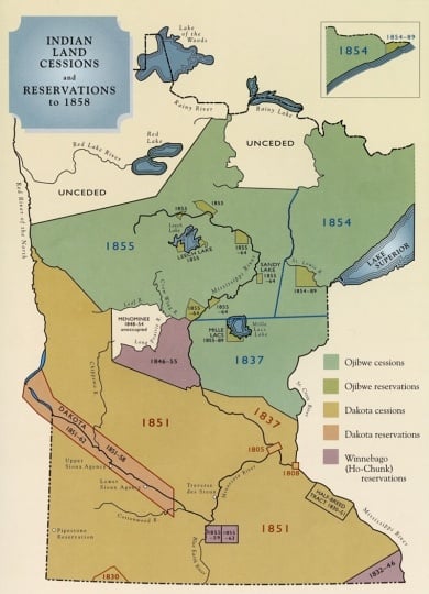
From land cessions to sovereign nations
These maps show different kinds of legal geography, so do not read them as a pixel-for-pixel land-loss calculation.
1862
Here the tone changes. The U.S.–Dakota War should not become another clever link in a chain. The geography matters, but so does the human suffering.
By 1862, the treaty and reservation system had sharply reduced the Dakota land base and disrupted older economies. Government payments and supplies were delayed, hunger became acute, settlement pressure increased, and relationships among Dakota people, traders, agents, settlers, and federal authorities deteriorated catastrophically.
Violence began in August and spread through the Minnesota River valley. Dakota fighters attacked the Lower Sioux Agency, Fort Ridgely, New Ulm, and other settlements. Settlers were killed and displaced. Some Dakota people participated in the fighting, while others opposed it, protected settlers, or helped captives. Minnesota forces eventually defeated Dakota fighters at Wood Lake in September.
The aftermath transformed Minnesota's human geography again. Thirty-eight Dakota men were executed at Mankato on December 26, 1862, the largest mass execution in U.S. history. Most Dakota people were then expelled from Minnesota regardless of individual involvement in the war. The result was not simply the end of a military campaign. It was another remaking of where people were permitted to live.
Six weeks of war
The earlier diagram did not show enough geography. This version uses the Minnesota Historical Society map and lets you zoom to key places while keeping the entire Minnesota River valley in view.

The reservation is not the homeland
A shaded polygon can quietly teach the wrong lesson. A reservation does not necessarily show where a people has always lived. Often it shows what remained after a much larger homeland was ceded or taken.
Later federal allotment policy fragmented reservation land further by dividing communal land into individual parcels. Large amounts of Native-controlled land subsequently passed out of tribal ownership. The reading traces this especially at White Earth and then notes the change in federal policy represented by the Indian Reorganization Act of 1934.
Territorial loss, however, is not the same thing as the disappearance of a nation. That distinction becomes crucial in modern Minnesota.
Homeland ≠ reservation
Step through four different kinds of political geography.
A homeland is a broad territory of political, cultural, economic, and spiritual relationships. It is not defined by a later reservation boundary.
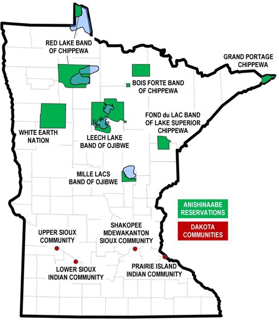
Eleven nations in modern Minnesota
Today there are eleven federally recognized tribal nations sharing geography with Minnesota: seven Anishinaabe reservations and four Dakota communities. Each is a distinct sovereign government.
This is why the old 2000 population bubble map in the source is no longer the map we need. Population is one question. Sovereign political geography is another. Students should first understand that modern Minnesota contains multiple tribal governments with their own government-to-government relationships with the United States and the State of Minnesota.
The eleven tribal nations sharing geography with Minnesota
A current Minnesota state map gives us the broad reservation and community geography.
Cities do not end Indigenous geography
After World War II, increasing numbers of Indigenous Minnesotans lived in urban areas, especially Minneapolis and St. Paul. Reservation geography and urban Indigenous geography coexist.
A person can live in Minneapolis and retain kinship, political, cultural, ceremonial, or economic ties to a tribal nation elsewhere in Minnesota. Students sometimes imagine reservation boundaries as cultural fences. They are not. Urban Native institutions and communities became important parts of the Twin Cities, while people continued moving between cities and reservation communities for family, work, ceremony, politics, and community life.
The story therefore does not move from Indigenous Minnesota to modern Minnesota. Indigenous Minnesota is inside modern Minnesota.
A treaty does not evaporate
Most old documents become interesting mainly to historians. Treaties can remain law. That means nineteenth-century agreements can reappear in modern disputes involving hunting, fishing, land, jurisdiction, and government authority.
The paper gets old. The legal relationship does not necessarily disappear. That is why treaty history matters beyond 1862, and it leads to the broader concept that survived enormous territorial loss: tribal sovereignty.
What survived?
Land loss was immense, but not every political relationship disappeared with the land.
Treaty rights
Treaty provisions can remain legally significant long after the landscape and population around them have changed. Old political geography can cast a very long legal shadow.
still presentAnd somehow we end up at a casino
The old reading spends pages describing slot machines, buffets, smoking, hotel towers, and rumored profits. Most of that can go. The much more interesting question is why a tribal nation can operate gaming on tribal land in the first place.
The answer is sovereignty. Congress enacted the Indian Gaming Regulatory Act in 1988, creating the federal framework for gaming on Indian lands. Class III gaming operates through tribal-state compacts. A tribal casino is therefore not simply a business that happens to be Native-owned. It exists within a distinctive legal geography involving sovereign tribal government, federal law, tribal land, and relations with the state.
Now follow the chain backward. Gaming. Compact. Federal Indian law. Sovereignty. Treaties. Reservation geography. Land cessions. Fur trade. Indigenous routes. Water. Suddenly the casino belongs in this chapter, not because blackjack is connected to beaver hats, but because sovereignty is.
Follow it backward
Begin with a modern tribal enterprise and move back toward the geography underneath the whole story.
What changed?
The easiest way to tell this story would be to divide it into eras: first Indigenous people, then voyageurs, then settlers, then reservations, then modern tribal nations. Geography makes the story more interesting because those layers refuse to remain separate.
The Grand Portage existed before the North West Company. The fur trade depended upon Indigenous technology and knowledge. Fur-trade credit became entangled with treaty payments and land cessions. Treaties transformed territory without making tribal nations disappear. Reservation lands were fragmented, yet sovereignty survived. Sovereignty then shaped modern political and economic geography.
One layer did not simply replace another. It accumulated over it. That is why a modern Minnesota map can contain Interstate 94, the Mississippi River, nineteenth-century treaty rights, tribal governments, reservation land, Dakota and Anishinaabe place names, historic fur-trade routes, and contemporary tribal enterprises. They belong to different moments. They occupy the same Minnesota.
And between the two there is a beaver hat, a ninety-pound bundle, a screaming wooden cart, an eight-and-a-half-mile trail through the forest, and an awful lot of Minnesota water.
Which seems about right.
1. Why were rivers and lakes so important to the early fur trade?
2. Why is Grand Portage a good example of relative location?
3. Why does the fur-trade story connect to the treaties of 1851?
4. Why is a reservation not the same thing as a homeland?
5. Why does tribal gaming belong in this chapter?
Next: Chapter 3.2
This section followed movement through water, trade, land cessions, and sovereignty. The next reading can take a different route through Minnesota's human landscape rather than simply continuing the same chronology.


Comments
Post a Comment