6.2 Small Towns: The Six Mile Machine
The Six-Mile Machine
A farmer needs a store. A horse determines how far the farmer can go. A railroad discovers roughly the same spacing useful. Then the automobile makes the whole arrangement obsolete, except that the towns refuse to disappear.
The Six-Mile Town
The first question is not why Minnesota had so many little towns. The first question is how far a farmer could conveniently travel.
Suppose you are a Minnesota farmer in 1875. You have butter and eggs to sell, a broken tool to replace, perhaps a letter to mail, and if things have gone particularly badly, a doctor or lawyer to see. You also have a horse, and that horse is going to help determine the map of Minnesota.
A nineteenth-century farm family could produce a remarkable amount for itself, but not everything. Farmers needed stores for tools, cloth, furniture, hardware, and manufactured goods. They needed blacksmiths, bankers, doctors, churches, schools, lumberyards, coal yards, grain buyers, mills, and eventually creameries. These things did not need to be visited every day, but they had to be close enough for a trip into town and back before dark.
With a horse and wagon, that usually meant something on the order of six to ten miles. A transportation technology had therefore created a geographical radius. Put farms across a landscape, give each family roughly the same travel limit, and add businesses that need customers. Pretty soon little service centers begin appearing, each surrounded by a hinterland of farms.
The small town was not merely a collection of buildings. It was a machine for reducing distance, and that helps explain why Minnesota acquired so many of them.
Interactive: How Far Can You Get?
Change the transportation technology and watch the practical trade area expand. As it grows, the nearest town loses its monopoly.
groceries • blacksmith • bank
more stores • doctors • courthouse
specialized shopping • services
The Town as a Toolbox
A tiny settlement might support only a grocery store, filling station, café, or tavern. A somewhat larger place could add a bank, drugstore, hardware store, lumberyard, furniture shop, hotel, funeral home, farm-supply business, and more specialized services. Larger regional towns offered still more stores, professionals, wholesalers, and institutions.
Geographers describe this as a trade-center hierarchy. The principle is familiar even if the terminology is not. You might travel a few miles for milk or gasoline, farther for a tractor, and farther still for specialized medical care. A small town serves the countryside around it, while a larger town serves both its own countryside and several smaller towns.
Population alone therefore does not completely explain the importance of a place. What matters is also what the place does. A town is a bundle of functions, and those functions change whenever transportation changes.
The farther people are willing and able to travel, the fewer complete service centers a region needs. A transportation revolution can therefore reorganize the settlement system without physically moving a single town.
Before the Railroad, Follow the Water
Minnesota's earliest important towns tended to appear along navigable rivers. This was not because nineteenth-century settlers had an unusually refined appreciation for waterfront property. Before railroads and highways, water was transportation infrastructure.
St. Paul, Minneapolis, Winona, Red Wing, and Hastings developed along the Mississippi. Stillwater grew on the St. Croix, while Mankato occupied an important position on the Minnesota River. These places were connected to markets and manufacturers in the older settled regions farther east.
Many also processed products from the surrounding countryside. Grain could be milled before shipment, animals could be slaughtered near where they were raised, and milk could be turned into butter or cheese. Processing locally often reduced the amount of useless material that had to be transported, so mills, creameries, elevators, warehouses, and workshops became part of the town.

Then, after about 1870, somebody changed the system. The railroad arrived, and Minnesota's little towns began multiplying away from the rivers.
The Railroad Draws the Map
Railroads did not simply connect Minnesota settlements. In many parts of the state, they decided where the settlements would be.
String Some Towns Along the Track
A railroad company crossing prairie country needed places for track maintenance, water, fuel, freight handling, passengers, and commerce. The companies also controlled land they wanted to sell, and settlers were particularly useful customers. They bought railroad land, produced commodities that traveled out by rail, ordered manufactured goods that traveled in by rail, and sometimes bought passenger tickets besides.
Railroads therefore promoted settlement aggressively and platted towns at intervals along their lines. Here the old horse-and-wagon geography met the new railroad geography in a surprisingly convenient way. Towns spaced roughly six to ten miles apart worked reasonably well for rural customers traveling by horse, while regular stops also served railroad operations and maintenance.
The result is still visible on Minnesota maps. Old rail corridors are decorated with towns, one after another across the prairie: another Main Street, another water tower, another grain elevator, another little cluster of streets. The original reading compares them to lights strung along a Christmas tree, and that is not a bad description at all.
Mini-Game: Build the Railroad Town System
Click along the railroad to place up to five towns. Try to serve as many farms as possible without piling towns directly on top of one another.
You Can Read the Railroad in the Streets
Walk through an old Minnesota railroad town and the nineteenth-century transportation system is often still there, hiding in plain sight. The original town grid frequently follows the railroad rather than the compass because the tracks were there first and the town was organized around them.
If the settlement later expanded beyond the original railroad plat, newer streets might run north-south and east-west instead. Where the two systems meet, the streets bend awkwardly. That bend is history written into pavement. In some places Main Street parallels the tracks; in others it runs away from them toward a courthouse or other public building.
Near the tracks often stands another familiar Minnesota object: the grain elevator. Even where railroad service has changed and the surrounding town has acquired new functions, the elevator still announces what the original settlement system was designed to do.

The railroad also divided town land by function. Commercial lots clustered near Main Street, warehouses and industrial businesses wanted track access, and residential lots spread farther away. The town plan was not simply an arrangement of streets. It was an economic diagram.
Too Tough to Die
By about 1900, the basic Minnesota small-town settlement system was largely in place. Then something surprising happened: it stayed there. Businesses changed, railroads disappeared, schools consolidated, and populations rose and fell, but remarkably few incorporated places vanished altogether.
Once people build streets, houses, churches, water systems, cemeteries, businesses, and governments, a settlement becomes difficult to erase. Places have inertia.
The source gives an almost comic example in Tenney, in western Minnesota. Tenney incorporated in 1901 with 185 people and spent much of the twentieth century losing population. By 1990 only four residents remained. Then came the great Tenney population boom of the 1990s, when its population increased by 50 percent.
It had risen from four people to six. That is why percentages require adult supervision. Tiny places can produce spectacular growth rates without producing very many additional residents.

The story continued
Tenney had only a handful of residents remaining by the beginning of the twenty-first century. In 2011 the municipality disincorporated and became part of Campbell Township. The government disappeared, but the place remained on the landscape.
Henry Ford Changes the Rules
The horse helped produce the small-town map. The automobile did not erase that map, but it changed what the dots on it were allowed to do.
The Model T Arrives
For several decades, the old geography worked. The farmer needed the nearby town because the horse could travel only so far. Then the automobile appeared, and suddenly six miles was nothing. Neither was ten.
A farmer who once had little practical choice but to shop in the nearest town could now drive to a larger place with more stores, more specialized services, and often lower prices. Trucks changed things as well because businesses could receive freight without sitting directly beside a railroad.
The distance barrier that had created hundreds of small trade centers began collapsing. This is why the decline of traditional Main Street cannot simply be blamed on Walmart, shopping malls, or some distant corporate executive. The deeper change began much earlier. The Model T had already altered the geometry.
Once people could travel farther, the local grocery competed with a supermarket twenty miles away, the local clothing store with a department store, and the local hardware shop with a larger retailer in the county seat. The automobile did not destroy the small town, but it removed one of the fundamental geographical reasons for having so many complete little service centers.
Time Machine: Watch the Town's Center of Gravity Move
Drag through time. The buildings remain, but transportation changes where people actually go and what the old buildings are used for.
Main Street Moves Toward the Highway
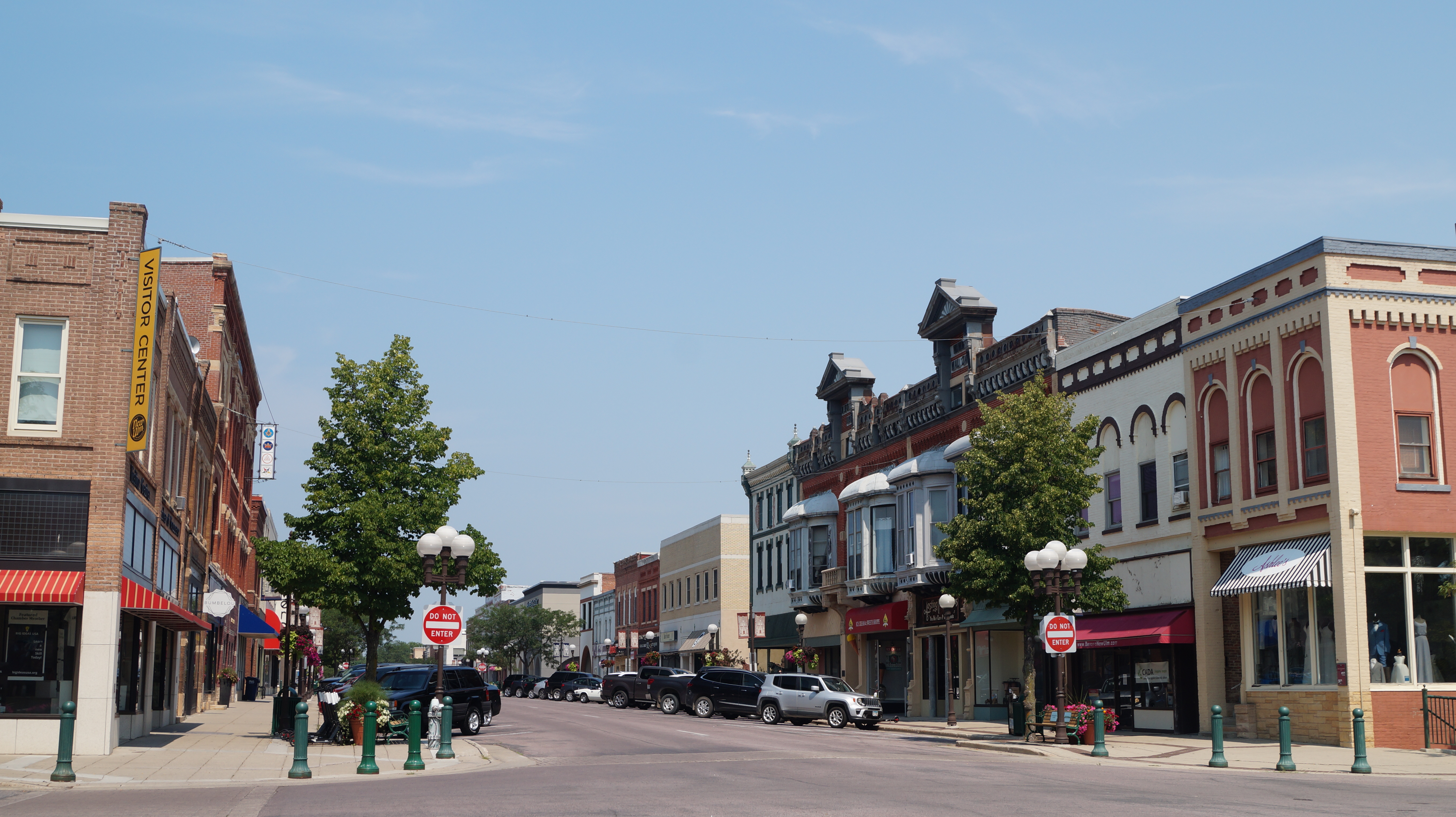
Drive into many Minnesota towns and the results remain visible. The old Main Street may still be handsome, with two-story brick buildings containing a café, bar, insurance office, antique store, apartments, municipal offices, or businesses quite different from those for which the structures were originally designed.
Then drive toward the edge of town and another landscape appears. There are gas stations, motels, fast food, supermarkets, clinics, farm-supply businesses, and sometimes big-box stores. The economic center has migrated toward the highway.
Again, transportation writes itself onto the landscape. The railroad once pulled commerce toward the tracks. The automobile pulled commerce toward the highway. Main Street did not necessarily die. It lost its monopoly.

Why Some Towns Grew and Others Did Not
The historical population patterns in the source show that Minnesota's larger small towns generally fared better than its tiniest ones. Many of the smallest railroad towns, particularly settlements founded relatively late on the western prairie, never became large enough to support many specialized functions before the automobile made some of those functions unnecessary.
A town with fifty or one hundred people has very little margin for losing a grocery store, bank, school, or employer. A town with several hundred or several thousand people has more possibilities. In the source's historical analysis, places that had reached roughly 350 residents were much more likely to display the solid Main Street blocks and continuing population stability associated with more durable towns. That roughly 350-resident figure belongs to the historical pattern analyzed in the source; it is not a universal threshold for whether a town succeeds.
The date a town was founded therefore mattered. Earlier places had more time to grow before transportation changed the rules. Some of the smallest prairie towns arrived relatively late. They had barely finished building the old machine before somebody changed the machine.
Most incorporated places were still gaining population. The settlement system itself was expanding.
The first great automobile decade produced a conspicuous increase in small-town population losses in the source's historical analysis.
Growth was increasingly associated with commuter zones, recreation regions, highway corridors, and towns that had acquired new functions.
The original reading was written around Census 2000 data and uses maps comparing earlier decades, especially 1950–2000. Those figures are useful here as historical evidence of how the settlement system changed rather than as present-day statistics.

The old town map is still being sorted
The automobile and highway era did not produce one simple rural outcome. Some counties lost population, some changed little, and growth remained especially strong around the Twin Cities and selected regional centers.
This helps update the source's older 1950–2000 comparisons. The old settlement pattern persists, but people continue redistributing themselves among commuter belts, regional centers, recreation areas, and places with new economic functions.
Local growth has never followed a simple rule. Neighboring places can behave very differently. One gains population while another loses it. A highway interchange appears, a hospital closes, a factory expands, a lake becomes desirable real estate, a school consolidates, or a family business unexpectedly begins selling products around the world.
Geography creates possibilities. It does not issue guarantees.
The Town Finds Another Job
The agricultural service center loses its old monopoly. The town survives by becoming something else.
The Town Learns a New Function
If the original small town existed mainly to serve nearby farmers, what happens when farmers no longer need that service center in the same way? The town finds another job.
Some Minnesota towns became commuter communities. People live there but drive somewhere else to work, so the town no longer needs to contain everyone's employment. Rather neatly, the same automobile that weakened the old Main Street can also help preserve the town by allowing people to live farther from their jobs.
Other communities serve lakeshore recreation and retirement areas. Some became medical or educational centers. Others found new functions in manufacturing, and manufacturing produces one of the more interesting transformations in the entire story.
The Factory Leaves the Big City
In the middle of the twentieth century, Minnesota manufacturing employment was heavily concentrated in Minneapolis and St. Paul. The source's 1950 and 2000 maps show how dramatically that pattern changed over the next half century as manufacturing became increasingly important across southern Minnesota and in several notable pockets farther north and west.
Warroad became strongly associated with Marvin windows, Roseau with Polaris, and Thief River Falls with snowmobile manufacturing. Alexandria developed a diverse manufacturing economy containing both branch plants and locally created firms. Those examples are not merely historical. Warroad remains Marvin's headquarters, Polaris describes Roseau as its largest U.S. manufacturing operation, and Arctic Cat restarted vehicle production in Thief River Falls in 2025 under new ownership.
This makes sense once transportation and technology change again. A modern factory does not necessarily need to stand beside a coal field, major river, or downtown rail terminal. Highways, trucks, electricity, and telecommunications loosen some of the geographical constraints that once concentrated industry in large cities.
So the sequence becomes wonderfully circular. The railroad creates the town. The automobile weakens its old retail function. The truck and highway help give some towns a manufacturing function. One technological system undermines the old geography while helping create the next one.


The company continues to operate from its founding headquarters in Warroad while manufacturing across a much larger national network.
Polaris identifies Roseau as its largest U.S. manufacturing operation, producing snowmobiles and off-road vehicles.
After a period of uncertainty, a new ownership group restarted vehicle production in 2025 and continued rebuilding the Minnesota operation into 2026.
The Factory in the Grocery Store
Some rural manufacturing arrived in shiny industrial parks. Some did not. The source gives a wonderfully strange example from Danvers, a tiny town in Swift County. In the late 1980s, an entrepreneur installed fifteen sewing machines in an abandoned grocery store and hired local women to manufacture compression garments for people recovering from liposuction surgery.
There is almost an entire geography course hidden inside that example. A building created for the town's old retail economy becomes obsolete. Its low cost attracts a manufacturer. Local labor connects a tiny western Minnesota settlement to a highly specialized medical market somewhere else entirely, and the product has almost nothing to do with the farms surrounding the town.
Changing transportation and communications systems loosen the relationship between what a place makes and what physically surrounds it. A small-town factory can make nearly anything if it has the necessary labor, capital, skills, transportation, and access to markets.
And Now We Need Workers
That produces the next connection. A town wants a factory, and the factory needs workers. Many rural Minnesota counties had spent decades losing young adults while farm populations declined and families became smaller. Eventually the supposed advantage of an inexpensive rural labor force runs into a rather obvious difficulty: there may not be enough workers.
Employers begin recruiting from farther away, and immigration becomes part of the small-town story. The source describes employers bringing Latino workers to food-processing jobs and other companies trying to recruit Southeast Asian workers from the Twin Cities. By the late twentieth century, new immigrants were already reshaping communities that had themselves been built generations earlier by German, Scandinavian, Czech, Polish, Finnish, and other immigrants.
There is a historical symmetry here. A town may regard newcomers as outsiders. A generation passes, and the descendants of those outsiders begin telling the next newcomers what the town has always been like. Minnesota has been doing this for quite a while.
The Small Town Is Not Frozen in Amber
There is a temptation to talk about small towns as if they preserve an older and somehow more authentic Minnesota. That can turn living places into museum exhibits.
Real towns are much messier. They contain generosity and gossip, newcomers and old families, farmers and factory workers, retirees and teenagers who cannot wait to leave. They contain people who left and unexpectedly came back, and people who have not spoken to one another for twenty years because of something involving a property line, a school-board election, or possibly a boat trailer.
The romantic Main Street is real enough, but so are empty storefronts, apartment conversions, industrial parks, highway businesses, immigrant-owned stores, clinics, warehouses, and commuters leaving town early in the morning. Small-town Minnesota is not simply an old landscape that somehow survived. It is a landscape continually being renegotiated.
One Town Does Not Need Everything
The automobile weakened individual small towns partly because it allowed people to leave town for goods and services. Yet the same mobility can connect neighboring towns into something larger.
A person can live in one town, work in another, send children to school in a third, receive medical care in a fourth, and shop in a fifth. At that point, the meaningful geographical unit is no longer necessarily the individual municipality. It is the network.

The hierarchy has become regional
Federal statistical areas give us one contemporary way to see the idea behind the reading. Metropolitan and micropolitan areas group counties around population cores and commuting relationships. They show that daily life often operates at a scale larger than one municipality.
The boundaries are statistical, not a map of continuous pavement. A county can belong to a regional labor and service system while still containing farms, small towns, lakes, and open land.
Interactive: A Day in the Dispersed City
You live in one town. See how ordinary daily activities connect several separate places into a single functional region.
Town A
Town B
Town C
Regional Center
Town D
Recreation Area
One town may specialize in health care, another in education, another in manufacturing, another in recreation, and another in housing. Together they perform some of the functions that an earlier generation expected every town to provide independently.
In that sense, rural Minnesota may be developing dispersed cities without quite realizing that this is what they are. The buildings do not touch. The functions do.
Does Minnesota Have Too Many Towns?
The original source makes a deliberately provocative argument that Minnesota created more tiny incorporated places than a modern economy actually requires. There is some logic behind the question. The railroad system produced a very dense pattern of settlements, while modern transportation makes it unnecessary for every six-mile interval to contain a complete set of services. Tiny municipalities can struggle to maintain roads, utilities, emergency services, public buildings, and local government with very small tax bases.
But population is not the same thing as usefulness, and usefulness is not the same thing as worth. A small town may survive without ever becoming a large one. The more interesting question may therefore be not whether every settlement can grow, but what each place is now for.
What Makes a Town Survive?
Nostalgia alone will not do it. A town cannot make 1895 return by hanging flower baskets on Main Street, pleasant as the flower baskets may be.
The towns most capable of surviving are those willing to ask what their function has become. Perhaps it is manufacturing, tourism, commuting, retirement, health care, education, food processing, or some business nobody has thought of yet operating out of a building originally designed for something entirely different.
Change is not evidence that the town has failed. Change is why the town exists in the first place. Minnesota's small towns were created by earlier technological and economic transformations: rivers, railroads, mechanized farming, telephones, electricity, automobiles, highways, trucks, and changing markets.
There was never one timeless small-town Minnesota. There were only different versions.
The six-mile machine
A farmer needs supplies, so the horse determines how far the farmer can conveniently travel. That distance helps establish the spacing of towns. The railroad discovers that similar spacing is useful and reinforces the pattern. Businesses line Main Street, elevators rise beside the tracks, and people build churches, schools, banks, homes, and courthouses.
Then the automobile makes six miles trivial. Commerce shifts toward the highway, manufacturing spreads outward, people commute farther, employers recruit workers from farther away, and neighboring towns begin sharing functions. The old geography does not vanish. It becomes the framework for the next one.
A Place History Keeps Reusing
That may be the most useful way to understand Minnesota's small towns. They are not simply places left behind by history. They are places that history keeps finding new uses for.
A grain elevator can outlive the railroad economy that made it important. A grocery store can become a factory. A storefront can become an apartment. A former retail center can become a commuter town. Five separate towns can begin functioning like pieces of one city.
In the long run, a town is neither its grain elevator nor its Main Street nor the population printed on the city-limit sign. It is a continuing decision by people that this particular place is still worth making into something.
Main Points
- Transportation technology changes the practical distance people can travel, and therefore changes how many complete service centers a region needs.
- Railroads reinforced the closely spaced town system that horse-and-wagon travel had already made useful across agricultural Minnesota.
- Automobiles and highways weakened the old monopoly of Main Street while allowing commerce, jobs, and daily life to spread across larger regions.
- Small towns persist because infrastructure, institutions, property, and social ties give places inertia, but survival often requires a new economic or social function.
- Modern Minnesota is increasingly organized through networks of towns and regional centers rather than self-contained settlements that each provide everything.
Glossary
Check the Connections
The point is not to memorize which little town had which store. Follow the chain of geographical causes.
Sources, image credits, updates, and further reading
- Original course reading: “Small Towns,” supplied document.
- Minnesota Historical Society / MNopedia materials on Minnesota towns, transportation, settlement, and railroads.
- Minnesota State Demographic Center materials documenting Tenney's disincorporation in 2011.
- Carol M. Highsmith photograph of Sleepy Eye, Minnesota, Library of Congress.
- Red Wing photograph, Wikimedia Commons.
- Hope, Minnesota grain elevator photograph, Wikimedia Commons.
- Tenney, Minnesota photograph, Wikimedia Commons.
- New Ulm historical street photograph, U.S. EPA / National Archives.
- Modern New Ulm street photograph, Wikimedia Commons.
- Marvin manufacturing photograph, Warroad, Wikimedia Commons.
- Polaris Experience Center photograph, Roseau, Wikimedia Commons.
- U.S. Census Bureau, Vintage 2025 Population Estimates and 2020 TIGER/Line county boundaries, used for the 2020–2025 population-change map.
- U.S. Office of Management and Budget / U.S. Census Bureau, July 2023 metropolitan and micropolitan statistical-area delineations.
- Marvin company materials, 2024–2026, on the Warroad headquarters, manufacturing, and rural worker recruitment.
- Polaris, Roseau, Minnesota location profile, describing Roseau as the company's largest U.S. manufacturing operation.
- Arctic Cat company updates, 2025–2026, documenting new ownership, renewed hiring, and restarted production at Thief River Falls.


Comments
Post a Comment