8.2 Inside the Central Cities: The City Beneath the City
The City Beneath the City
A ravine becomes an immigrant village and then a park. A river flat becomes a neighborhood, then a terminal, then green space. Churches move uphill, streetcars leave ghosts in the streets, and one generation's cheap housing becomes another generation's historic district. Minneapolis and St. Paul do not replace themselves very neatly. They accumulate.
By the end of this reading, you should be able to...
Cities are terrible at cleaning up after themselves. They tear down buildings, bury creeks, abandon rail lines, reroute commerce, and rename neighborhoods, but the older city usually refuses to disappear completely. A street bends for a railroad that no longer runs. A church serves a population that arrived generations after the people who built it. A park occupies the precise ravine where a thousand people once lived without plumbing.
John S. Adams and Barbara J. VanDrasek's Minneapolis-St. Paul: People, Place, and Public Life is especially useful because it catches the central cities at a particular moment, roughly the end of the twentieth century, and asks students to look beneath the metropolitan surface. Their city is full of old job districts, immigrant neighborhoods, parish boundaries, streetcar corridors, housing rings, parks, and social institutions. We will keep that historical endpoint visible rather than pretending a 1990-era description is a 2026 description, then add a short epilogue showing what happened next. Urban palimpsest is the fancy term. "The city beneath the city" is easier to remember.
First, find the old machine
Before neighborhoods become cultural landscapes, people need work, transportation, and somewhere they can afford to live. The early Twin Cities organized those things around downtowns, industrial corridors, railroads, and river crossings.
Adams and VanDrasek describe early Minneapolis and St. Paul as having a kind of "figure eight" geography. In each city, an export-base economy clustered around places where raw materials, factories, rail lines, and outside markets met. Local service jobs clustered nearby because workers and households needed food, clothing, banking, entertainment, and everyday services. Residential districts then wrapped themselves around those job centers.
The result was never socially neutral. In Minneapolis, prosperous households increasingly occupied attractive land toward the lakes and southwest of downtown, while industrial and immigrant districts followed rail corridors and lower-cost land. St. Paul's elite gathered around Summit Hill, while working-class and immigrant communities developed on the East Side, West Side, and along industrial corridors. The central business district was one layer of the city; class, ethnicity, land value, and transportation produced several others.
Peel back the city
Keep the rivers and downtowns fixed. Add one historical layer at a time. The diagram is conceptual, but every layer represents a process Adams and VanDrasek describe in their account of the central cities.
This layered structure helps explain why the city could contain sharply different neighborhoods only a short distance apart. A railroad embankment, factory belt, bluff, river flat, or ravine could reduce land value and separate one residential district from another. At the same time, those low-cost places could be extremely valuable to people just arriving because they were close to jobs and because relatives, friends, churches, shops, or people speaking the same language were already nearby.
That is the geography of a landing place. The neighborhood may look marginal from the outside while functioning as an extraordinarily useful social machine from the inside. Two of the best examples were tucked into terrain the wealthier city did not especially want.
The ravine becomes a ladder
Swede Hollow was physically below the city and economically below most of it too. That very marginality made it one of St. Paul's most useful immigrant entry points for nearly a century.
Swede Hollow occupied the ravine of Phalen Creek beneath Dayton's Bluff on St. Paul's East Side. Swedish immigrants settled there in the late 1850s, close to railroad, brewery, mill, and industrial work. MNHS records more than one thousand people in the Hollow by the 1905 state census. The housing lacked indoor plumbing and electricity, and the ravine itself was physically separated from the wealthier city above, but residents created families, friendships, traditions, and networks that made the place work.
The important story is what happened when the Swedes began to leave. Italians, Irish residents, and later Mexican and Mexican American families moved into many of the same inexpensive structures. This is neighborhood succession: the buildings remain while the social geography changes. A neighborhood's name can even outlive the population that gave it the name.

Keep the ravine. Change the city living inside it.
The physical hollow stays roughly in place while the population, economic role, and official meaning of the landscape change.
After the health department deemed conditions hazardous, sixteen remaining families were forced to leave. On December 11, 1956, the fire department burned the thirteen houses still standing. In October 1976, the city dedicated the ravine as a nature center. That is an extraordinary land-use transformation: immigrant housing became condemned housing, condemned housing became cleared land, and cleared land became an urban park. The valley did not move. The city's definition of the valley changed.
Minneapolis had a village under the bridge
Bohemian Flats performed a similar job on the Mississippi floodplain below the University of Minnesota. It was cheap because it was inconvenient, flood-prone, industrial, and literally beneath much of the city.
Immigrants began building homes on the west bank of the Mississippi in the 1860s. By 1900 roughly one hundred homes, stores, and a church formed what observers described as an Old World village below the Washington Avenue Bridge. Swedish, Norwegian, Czech, Irish, Polish, Slovak, and other residents used the Flats as an inexpensive foothold close to mills, breweries, railroads, and downtown employment. Family and village connections also encouraged chain migration, allowing a newcomer to arrive in a place where someone already knew how the city worked. MNHS now describes Bohemian Flats as one of the Twin Cities' important "landing place" communities.
The river made the neighborhood possible and repeatedly threatened it. Spring floods could enter houses and streets, but the Mississippi also supplied fish, salvaged lumber, transport, and work. City leaders increasingly valued the same riverbank for industrial purposes, however. Minneapolis first used eminent domain in 1915 to acquire land in the southern Flats for a barge terminal. In 1929 it began condemnation proceedings for a coal terminal. Most residents were forced out over the next two years. A small remnant of homes and residents persisted into the 1960s; by that decade the Flats' residential landscape was gone.


Cedar-Riverside keeps the landing-place function
Up the bluff, Cedar-Riverside changed without losing its habit of receiving newcomers. Scandinavian immigrants once made Cedar Avenue famous as a dense ethnic commercial corridor. The university expanded, urban renewal removed older structures, high-rise housing arrived, counterculture and arts institutions reshaped the West Bank, and later refugee communities added new institutions and businesses. Adams and VanDrasek's account ends before the largest Somali settlement period, which is exactly why it is useful to stop the historical narrative around 1990 and then look forward.
Somali refugees began arriving in Minnesota in the early 1990s. The Confederation of Somali Community in Minnesota organized in Cedar-Riverside in 1994, and MNHS continues to describe the neighborhood as a place of special significance to Somali American life. A building that once housed Scandinavian-era industry could become a Somali mosque; high-rise housing created for an earlier redevelopment era could become part of a new refugee geography.

Buildings are only half the neighborhood
Churches, synagogues, schools, markets, clubs, public housing, and mutual-aid institutions help explain why communities can remain geographically coherent even when individual families move.
Adams and VanDrasek devote considerable attention to religion because nineteenth- and twentieth-century immigrant communities did not simply occupy houses. They built institutions. Catholic personal parishes, Lutheran congregations, synagogues, schools, halls, charities, and businesses turned residential clusters into social landscapes. A family might move several blocks and still remain inside the same institutional world.
Jewish geography provides an especially clear example. German Jewish families established institutions in St. Paul and Minneapolis early, while later Eastern European Jewish immigrants created different residential and religious concentrations. Over time, households moved along recognizable paths toward newer neighborhoods and suburbs, while synagogues, hospitals, businesses, and social networks helped relocate community geography rather than simply dissolve it. The important map was never just "where do people live?" It was also "where are the institutions that make a population feel at home?"
A church can organize language, schooling, mutual aid, marriage networks, and neighborhood identity around one place.
Stores convert a residential concentration into an economic landscape and reduce the cost of maintaining culture in a new city.
Institutions turn a cluster of households into a durable community whose social geography can outlast its first generation.
The American Indian geography around Franklin Avenue and Little Earth deserves the same kind of attention. Native people from many tribal nations moved to Minneapolis during the twentieth century. Some came under the 1956 Indian Relocation Act, which encouraged movement from reservations to cities as part of a wider federal assimilation policy; others arrived through different family, work, and community paths. Little Earth was founded in 1973 in response to discrimination and the need for culturally connected housing. Today it remains a 212-unit, 9.4-acre, Indigenous-preference project-based Section 8 community with residents from many tribal nations.
That is not merely subsidized housing on a land-use map. It is an example of social capital taking physical form. A neighborhood can be valuable because the people and institutions inside it make life more workable, even when conventional measures describe the surrounding land as inexpensive or disadvantaged.
The streetcar is gone. Its city is not.
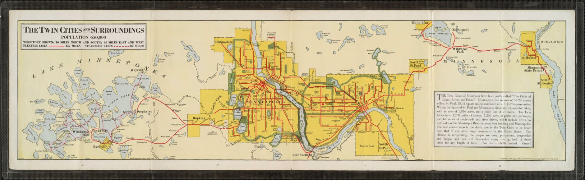
Transportation produced another hidden layer. Electric streetcars pulled housing outward in corridors, and then automobiles filled the land between them. Scheduled Twin City Rapid Transit streetcar service ended in 1954, but many of the neighborhoods remained.
Adams and VanDrasek's historical maps show the residential city extending outward along streetcar lines between the 1880s and 1920s. That pattern helps explain why some commercial corridors still feel more urban than nearby streets: stores, apartments, churches, and transfer points accumulated where people already moved. A streetcar suburb is therefore not merely a suburb with an old rail line. It is a built form created by a particular commuting technology.
This is where the previous reading, The City Drawn in Motion, and this reading meet. The earlier reading emphasized movement; this one asks what movement left behind. Kenwood, Loring Park, Dinkytown, Cedar-Riverside, Grand Avenue, Hennepin, Lake Street, University Avenue, and dozens of neighborhood centers still contain pieces of the transit-era city even when the rails themselves are gone.

Then somebody saves the lake before the houses arrive
Horace Cleveland understood that urban land becomes difficult to recover once private development claims it. His solution was simple and radical: preserve natural scenery before the city needs it badly.
Landscape architect Horace William Shaler Cleveland arrived in St. Paul in the 1870s arguing that a growing metropolis should reserve lakes, river edges, ravines, and scenic corridors as a "permanent heritage." Minneapolis adopted his advice more aggressively after creating a park board in 1883. Charles Loring and later Theodore Wirth extended the idea into the Chain of Lakes, Minnehaha, river parkways, and the interconnected Grand Rounds. Minneapolis Park and Recreation Board histories still trace the system's planning to Cleveland's 1883 plan.
The geography is easy to miss because the parks now feel natural. Public access around Lake Harriet or Bde Maka Ska can look as inevitable as the lake itself. It was not. Public shoreline is the result of decisions made before rising land values and private subdivision could make continuous access vastly more difficult.


When should the city protect the shoreline?
Run the same lake through two development decisions. This is conceptual, but the land-value logic is real.
The park system also demonstrates why a city cannot be understood as only buildings and roads. Parks influence nearby land values, public health, water, habitat, recreation, and who has access to natural amenities. They are part of the public realm, and they shape private investment around them.
In Adams and VanDrasek's 1990-era snapshot, metropolitan park planning was already carrying Cleveland's logic into the suburbs. That process continued. Today the Grand Rounds alone includes about 55 miles of parkways and 102 miles of walking and biking trail mileage. Separately, Three Rivers Park District, created by state law in 1957, manages more than 27,000 acres of regional parks, reserves, trails, and facilities.
1990 was not the ending
Adams and VanDrasek's account stops at a useful historical moment. Keeping that boundary visible lets us see what changed after it instead of silently rewriting the past into the present.
By 1990, Adams and VanDrasek could already see the Twin Cities becoming more diverse again after the long mid-century slowdown in immigration. Their maps captured Black, American Indian, Asian American, and Hispanic settlement patterns at that moment. Those maps should be read as dated evidence, not as current demographic truth. The point is to compare the 1990 layer with what later migration added.
Somali refugees began arriving in the early 1990s, and Cedar-Riverside became a major institutional and residential center of Somali American life. The neighborhood's landing-place function survived even as the population changed.
The 1973 community survived the financial uncertainty Adams and VanDrasek described and today houses nearly 1,000 residents with 38 tribal affiliations, alongside education, health, food-sovereignty, and cultural programs.
Bohemian Flats is parkland, Swede Hollow is a park, rail and streetcar alignments become trails or transit corridors, and immigrant commercial districts continue changing ownership without losing their urban importance.

The old city is still doing work
A neighborhood can change language, religion, class, architecture, and population without starting over. The older layer becomes material for the next one.
This is the part that makes urban geography less like memorizing neighborhoods and more like detective work. If a street bends, ask what it once followed. If a low-cost neighborhood sits beside a rail trench or floodplain, ask which earlier land market created that bargain. If a church seems oddly large for its current congregation, ask who built it and what community once lived around it. If a park occupies a ravine or river flat, ask who or what had to leave before the trees arrived.
The Twin Cities are full of urban morphology that outlasted the social system that created it. The figure-eight job districts, immigrant landing places, parish landscapes, streetcar fingers, river flats, lake parks, and neighborhood centers all became inherited infrastructure. That inheritance can be beautiful, unequal, useful, inconvenient, or all four at once.
The city beneath the city
Useful vocabulary
Quick check
1. Why did Swede Hollow function as a useful immigrant landing place despite poor housing conditions?
2. What is the most important lesson of neighborhood succession?
3. Why are churches, synagogues, schools, markets, and community organizations important to urban geography?
4. What does the streetcar map help explain even though the streetcars are gone?
5. What is the Cleveland shoreline lesson?
6. Why does this reading keep Adams and VanDrasek's 1990-era endpoint visible?
Works Cited & Further Reading
Foundational Works for the Minnesota Reader
Adams, John S., and Barbara J. VanDrasek. Minneapolis-St. Paul: People, Place, and Public Life. University of Minnesota Press, 1993.
Hart, John Fraser, and Susy Svatek Ziegler. Landscapes of Minnesota: A Geography. Minnesota Historical Society Press, 2008.
Tester, John R. Minnesota's Natural Heritage: An Ecological Perspective. University of Minnesota Press, 1995.
Twin Cities Public Television and Bell Museum of Natural History. Minnesota: A History of the Land. Four-part documentary series, 2005.
Sources Used and Updates for This Reading
Minnesota Historical Society / MNopedia, "Swede Hollow, St. Paul".
Minnesota Historical Society / MNopedia, "Bohemian Flats, Minneapolis".
Minneapolis Park and Recreation Board, Bohemian Flats Park history and Grand Rounds Scenic Byway System.
Little Earth Residents Association, community history and current profile.
Minnesota Historical Society / MNopedia, Confederation of Somali Community in Minnesota and Somali and Somali American Experiences in Minnesota.
Three Rivers Park District, 2026 operating materials, current system acreage and mission.
Minnesota Historical Society / MNopedia, Twin City Rapid Transit Company and electric streetcars.
Visual Sources
Historic Swede Hollow image: Minnesota Historical Society / MNopedia. Historic Bohemian Flats image: Minnesota Historical Society via Wikimedia Commons. Cedar-Riverside photograph: Fibonacci Blue, CC BY 2.0, via Wikimedia Commons. Hmongtown Marketplace photograph: Pingnova, June 2022, CC0, via Wikimedia Commons. Horace W. S. Cleveland portrait and 1894 Twin City Rapid Transit map: Wikimedia Commons. 1915 The Twin Cities and Surroundings map: Minnesota Streetcar Museum collection / Minnesota Digital Library, public domain. Lake Harriet historical image: DPLA / Wikimedia Commons.


Comments
Post a Comment