9.2 Minnesota a History of the Land: 4 Second Nature
Second Nature
Raymond Lindeman studied one small Minnesota lake and discovered a rule the rest of the state would spend decades learning the hard way: everything is connected, and everything goes somewhere.
By the end of this reading, you should be able to...
In December 1936, University of Minnesota graduate student Raymond Lindeman began collecting data at Cedar Bog Lake, now part of Cedar Creek Ecosystem Science Reserve near East Bethel. He began asking an oddly dangerous question: where does everything go? Nitrogen enters a lake, carbon moves through it, sunlight becomes plant tissue, an insect becomes fish, a fish becomes food for something larger. Lindeman was not satisfied with listing the organisms he found. He wanted to describe the lake as an ecosystem. His wife Eleanor helped him collect water, plants, microscopic organisms, crustaceans, worms, and fish for more than five years. Together they helped turn ecology from natural history into something capable of measuring relationships.
Lindeman died in June 1942, and his most influential work appeared posthumously in Ecology that October. He never saw what his idea would become. That same year the United States was fighting a world war, and the technologies of war were accelerating production, transportation, fishing, mining, construction, and consumption. Minnesota was acquiring extraordinary power to rearrange landscapes just as ecology was acquiring the language to explain the consequences. The timing was almost cruelly perfect.


Lindeman's trick: stop seeing species as separate things
Move up the food web. The exact numbers are illustrative; the point is the relationship. Energy is captured, used, lost as heat, and passed onward. The lake is not a list of organisms. It is a flow.
Lindeman asked how energy and nutrients moved through an entire ecosystem. Once you ask that question, no organism is isolated from what feeds it or what feeds on it.
A lake that looked limitless
Lake Superior had supported human communities for generations, and by the late nineteenth century Norwegian and Finnish immigrants were building commercial fishing lives along the North Shore. Whitefish were initially the great prize. Across Lake Superior, commercial lake-whitefish catch reached about 5.2 million pounds in 1885. Whitefish stayed relatively shallow and were easy to reach, which also made them easy to overharvest. When whitefish declined, fishermen moved toward lake trout. The resource seemed enormous because the lake itself was enormous. It was not. Overharvest can exhaust even a resource that looks limitless.


World War II intensified the pressure. Outboard motors expanded the range of fishermen. Nylon nets replaced cotton twine and increased catching efficiency. Then a different technology entered the story. Canals and locks designed to make the Great Lakes more useful to ships also increased biological permeability. The Welland Canal bypassed Niagara Falls. After major canal improvements, sea lampreys appeared in Lake Erie in 1921, Lake Michigan and Lake Huron in 1936 and 1937, and Lake Superior in 1938. The lake trout had never evolved with a parasite like this. Long-term harvest, more efficient fishing, and parasitism converged on the fishery.
Solve a transportation problem for ships. Solve it for organisms too.
Click through the engineering sequence. The percentage bars are a teaching schematic for rising access, not measured values of shipping capacity or invasion risk.
Canals, locks, and the sea-lamprey route
A barrier built for ships could become an opening for organisms. This is a connection diagram, not a scale map or the route of one individual lamprey.
Niagara Falls and other natural barriers made Lake Superior difficult to reach from the Atlantic for ships and organisms alike.
One pressure may bend a system. Several can push it past a threshold.
Turn on the pressures that converged on lake trout. Watch the top predator and the rest of the food web respond.
The model is conceptual, but the historical sequence is real: long-term harvest pressure was intensified by new fishing technology, then the sea lamprey supplied the final blow.


Three pounds go in. One pound comes out.
The next Lake Superior crisis begins with arithmetic. Minnesota's richest natural iron ores were being depleted, but taconite offered a new industrial future. Reserve Mining shipped its first taconite in 1955 and entered full production at Silver Bay in 1956. The technology worked. Crush the rock, separate the iron-bearing material, pelletize the concentrate, and ship it to steel mills. But a three-pound sample of taconite produced roughly one pound of useful concentrate and two pounds of waste. Industrial accounting called that material tailings. Ecology asks a different question through mass balance: where do those two pounds go?


The factory can rename matter. It cannot make matter disappear.
Move the production slider. The 1-to-2 product-to-waste ratio stays the same. At industrial scale the disposal question becomes the story.
Reserve ultimately dumped tens of thousands of tons per day. The environmental argument was never about whether the waste existed. It was about who would bear the consequences of where it was put.
The day the company met the ecosystem in court
By the early 1970s, Reserve was discharging about 67,000 short tons of tailings per day into Lake Superior. Fine particles created cloudy water, and residents and fishermen began demanding action. Arnold Overby, a Silver Bay teacher, helped form the Save Lake Superior Association. University of Minnesota Duluth students organized Students for Environmental Defense. National groups joined them. A public meeting in Duluth drew hundreds. The crucial change was not that one scientist suddenly discovered pollution. It was that citizens learned enough ecology to insist that the lake was part of the accounting.
The fight became ferocious because the company was not an abstraction either. Thousands of jobs and the survival of Silver Bay were tied to Reserve. Concerns about amphibole mineral fibers in drinking water made public health part of the case. Land disposal was not an impossibility: other Minnesota taconite operations used on-land tailings facilities, and Reserve had studied on-land options. In 1974, federal judge Miles Lord ordered the Silver Bay plant closed. An appeals court quickly stayed the order, and the company continued discharging while the case moved through the courts. The dumping finally ended in 1980 when an inland tailings system was completed.
Citizen concern becomes federal environmental law
Reserve begins shipments in 1955 and full Silver Bay production in 1956. Taconite promises jobs, steel, and a future for an ore region whose richest natural deposits are running out.
The same problem moves south and becomes a subdivision
Lake Superior made ecological cause and effect dramatic because a giant company dumped waste from an identifiable place. The next lesson was harder. What if the environmental change came from ordinary homes, ordinary roads, ordinary parking lots, and ordinary hopes for a larger yard? By the 1990s, suburban growth southwest of the Twin Cities was converting farmland, wetlands, and wildlife habitat at extraordinary speed. Scott County became one of the film's examples. A farm that had once stood outside Shakopee could become an island surrounded by houses within a generation.


The physical mechanism is almost embarrassingly simple. Soil and wetlands absorb water. Impervious surfaces do not. Rain falling on an impervious surface becomes runoff quickly, carrying sediment, nutrients, petroleum residues, salt, and other pollutants toward streams and lakes. One inch of rain over one square mile of asphalt produces more than seventeen million gallons of runoff. Around the Twin Cities, much of that water ultimately enters the Mississippi. In a headwaters state, "downstream" can mean hundreds or thousands of miles away.

Build the suburb. Then make the hidden costs visible.
Imagine that you have 36 acres of old farmland at the suburban edge. Paint the land one acre at a time, or try a preset. The numbers are simplified teaching values, not a professional planning model, but the tradeoffs are real.
Low density can preserve some open ground, but it spreads trips and infrastructure across more land. Try changing the housing mix before deciding which plan is actually "green."
A subdivision in Minnesota can reach South America
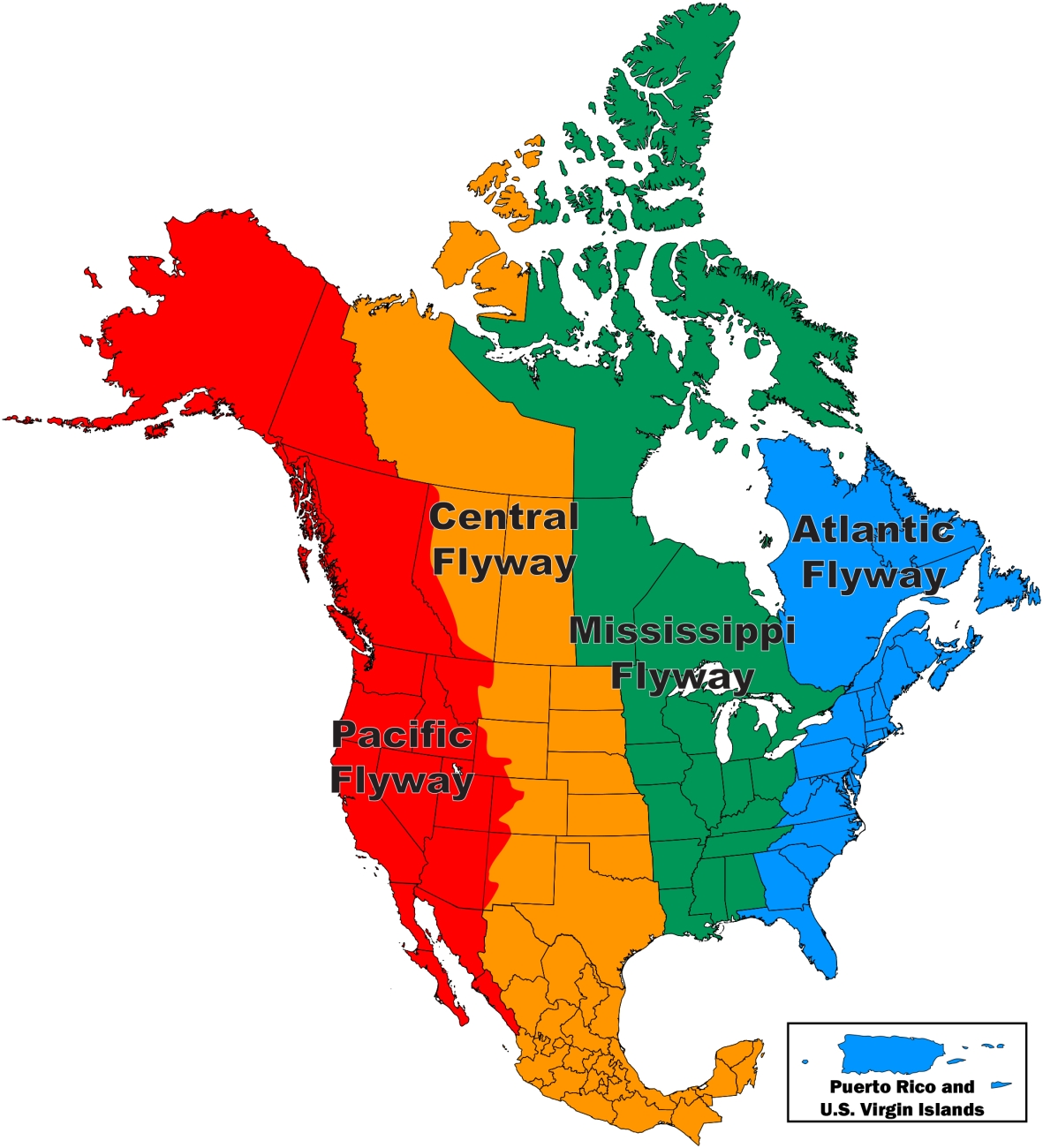
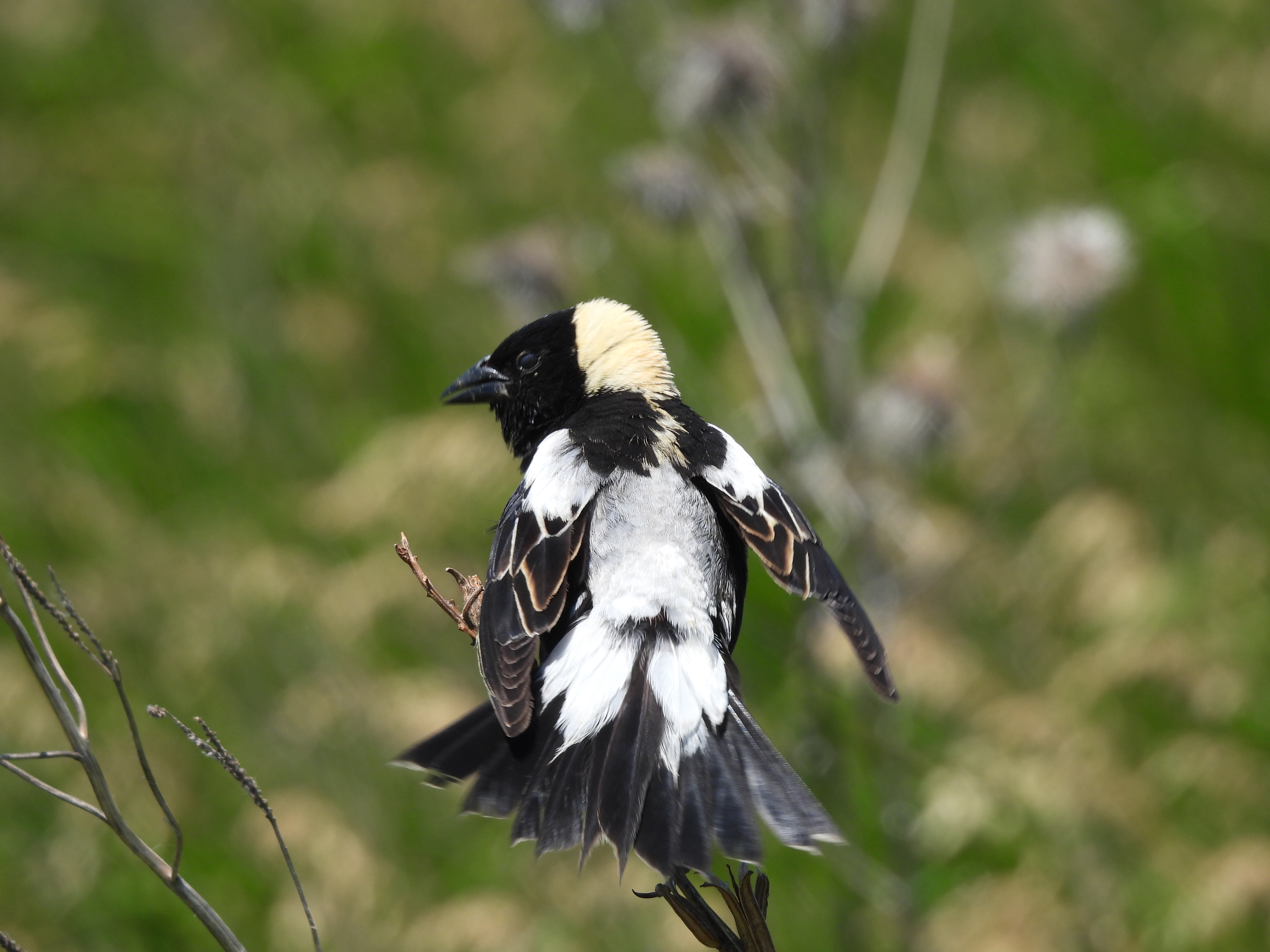
The final ecological leap is the largest. The Mississippi Flyway is a broad management corridor, not a promise that every Minnesota bird takes the same route. Yet migration still connects land-use decisions here to habitat far away. Habitat fragmentation near the Twin Cities therefore affects creatures whose annual geography ignores state and national boundaries. The film's Henslow's sparrow illustrates the grassland problem, but it winters chiefly in the southeastern United States. For the literal Minnesota-to-South-America connection, consider the bobolink, a grassland bird that breeds in Minnesota and winters in South America. A species can require Minnesota grassland in June and a different, distant habitat in January. Damage either end of the relationship and the whole life cycle is exposed. This is migratory connectivity.

There is no away
The episode ends by returning, in effect, to Lindeman's little lake. Minnesota had spent much of its modern history behaving as though landscapes could be separated into useful pieces: timber over here, fish over there, mine waste somewhere else, housing on that field, water down that storm sewer. Ecology keeps spoiling the neatness of those categories. Tailings do not vanish because they enter deep water. Rain does not vanish because it enters a drain. A bird does not become someone else's bird because it crosses the Gulf of Mexico. Topsoil scraped from a farm is not recreated merely because the subdivision built on the site has attractive lawns.
That does not mean the history is simply a catalogue of damage. Lake trout recovered. Citizens changed industrial practice. Water quality improved in many places. Parks and habitats were preserved. The striking thing is how often improvement began when people stopped treating the consequence as somebody else's problem and started seeing the system around it. The larger argument across all four episodes is precisely this: human beings simplify landscapes, encounter consequences that the simplified picture failed to predict, then adjust their ideas and their behavior.
The Pillsbury A Mill closed in 2003, more than a century after flour milling had become one of the great symbols of Minnesota progress. By then the state had traveled from clear-cut forests and wheat bonanzas to sewage treatment, wilderness preservation, fisheries restoration, pollution law, metropolitan planning, and ecosystem science. None of those later ideas erased the earlier history. They grew from it.
Raymond Lindeman began with a small lake because a small lake was large enough. Every nutrient had a history. Every organism had relationships. Every bit of energy had somewhere to go. Once you learn to see that, Minnesota itself begins to look less like a collection of resources and more like what it always was: one astonishing arrangement of connections.
What to carry forward
Useful vocabulary
Quick system check
Works Cited & Further Reading
Foundational Works for the Minnesota Reader
Hart, John Fraser, and Susy Svatek Ziegler. Landscapes of Minnesota: A Geography. Minnesota Historical Society Press, 2008.
Adams, John S., and Barbara J. VanDrasek. Minneapolis-St. Paul: People, Place, and Public Life. University of Minnesota Press, 1993.
Tester, John R. Minnesota's Natural Heritage: An Ecological Perspective. University of Minnesota Press, 1995.
Twin Cities Public Television and Bell Museum of Natural History. Minnesota: A History of the Land. Four-part documentary series, 2005.
Sources Used and Updates for This Reading
University of Minnesota College of Biological Sciences. Raymond Lindeman (1915-1942) and Cedar Creek history materials.
U.S. Fish and Wildlife Service. Taking Stock of Our Progress for Lake Trout, 2025; and Marquette Biological Station restoration update, 2026.
Great Lakes Fishery Commission. Sea-lamprey history, control materials, and current status.
Minnesota Historical Society / MNopedia. United States of America v. Reserve Mining Company and Commercialization of Taconite; 1974 federal court opinion.
Minnesota Pollution Control Agency. Minnesota Stormwater Manual, Minimal Impact Design Standards performance goals.
Myotus. Map of watersheds and basins in Minnesota (2021), CC BY-SA 4.0 via Wikimedia Commons.
Minnesota Department of Natural Resources. Minnesota watersheds map.
U.S. Fish and Wildlife Service. Mississippi Flyway and migratory-bird resources; Male Bobolink Displaying.
Minnesota Department of Natural Resources. Henslow's Sparrow Rare Species Guide and Prairie Songbirds (bobolink).
Cephas. Bobolink seasonal range map, 2009, CC BY-SA 3.0.
Great Lakes Fishery Commission. Sea Lamprey history and control materials.
Visual Sources
Lake trout packing and Reserve Mining plant images are course-guide assets from Minnesota Historical Society collections. Reserve tailings photographs are EPA DOCUMERICA / U.S. National Archives public-domain images. Other Great Lakes, fish, flyway, and wildlife photographs are U.S. Fish and Wildlife Service public-domain images or Wikimedia Commons images credited in their captions. The bobolink range map is by Cephas, 2009, CC BY-SA 3.0. The Great Lakes pathway graphic is a course teaching schematic, with chronology checked against the Great Lakes Fishery Commission.


Comments
Post a Comment